Göbekli Tepe
The Stone Age hilltop of carved T-pillars that pushed monumental architecture back before farming — and the argument over what it really was.
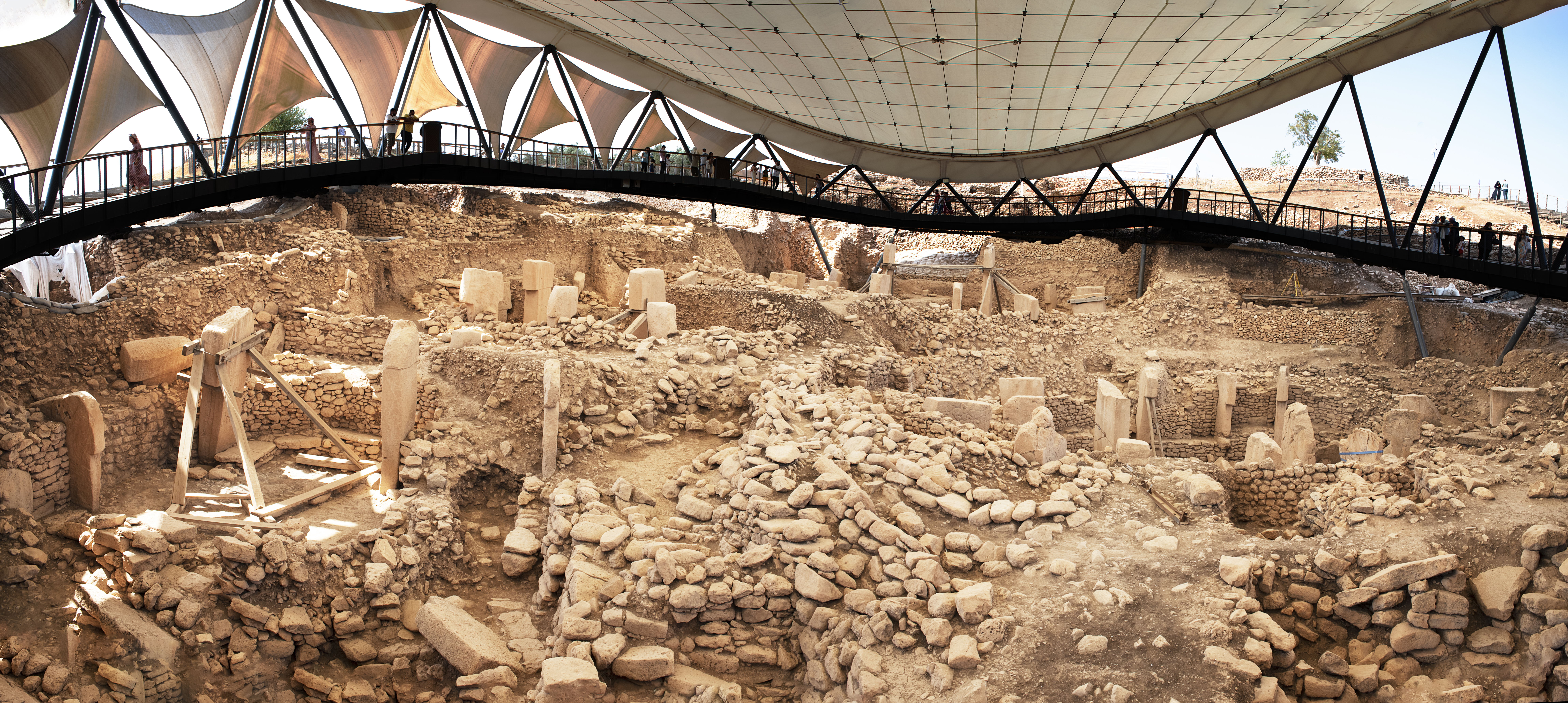
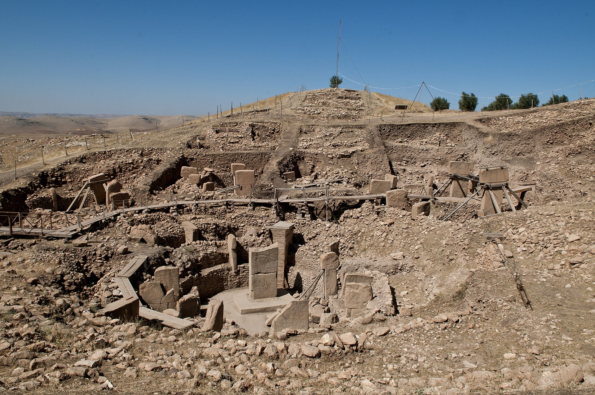
Göbekli Tepe is a tell on a limestone plateau in Şanlıurfa province, south-eastern Turkey, built and used in the Pre-Pottery Neolithic between about 9500 and 8000 BCE. Its older layer holds round-oval enclosures of T-shaped limestone pillars carved with wild animals, raised by people who were still hunter-gatherers and had no domesticated crops or animals. Klaus Schmidt, who began digging in 1995, read the enclosures as a sanctuary where mobile groups gathered and concluded that belief and monument-building came before farming; later work found domestic buildings, hearths, a sub-floor burial and rainwater cisterns at the site, and the excavators themselves now describe the buildings as communal or special-purpose rather than temples. Carved human skulls, an enormous stone 'totem pole' and buildings damaged by slope slides are among the finds reshaping the site's story.
In this article
- 1What is Göbekli Tepe?
- 2How old is the site, and how do we know?
- 3The enclosures and their pillars
- 4Enclosure A: snakes
- 5Enclosure B: foxes and dogs
- 6Enclosure C and D
- 7Animals, symbols and human figures
- 8Temple, settlement, or neither?
- 9The end: why was it abandoned and buried?
- 10Everyday life: food, water and labour
- 11Discovery and excavation
- 12World Heritage status and threats
- 13What the site changed in archaeology
- 14The meaning of the pillars
- 15Where exactly is it, and how big is the property?
- 16Skulls, bones and the dead
- 17Layer II: what came after the big circles
- 18What the stones still hide
- 19Timeline
- 20Frequently asked questions
- 21Knowledge graph
What is Göbekli Tepe?
UNESCO describes Göbekli Tepe as a property in the Germuş mountains of south-eastern Anatolia whose round-oval and rectangular megalithic structures were raised by hunter-gatherers between 9,600 and 8,200 BCE. The reddish-brown tell is up to 15 m high and 300 m across, sits on the highest point of the Germuş range and forms a prominent landmark at the edge of the Harran plain.
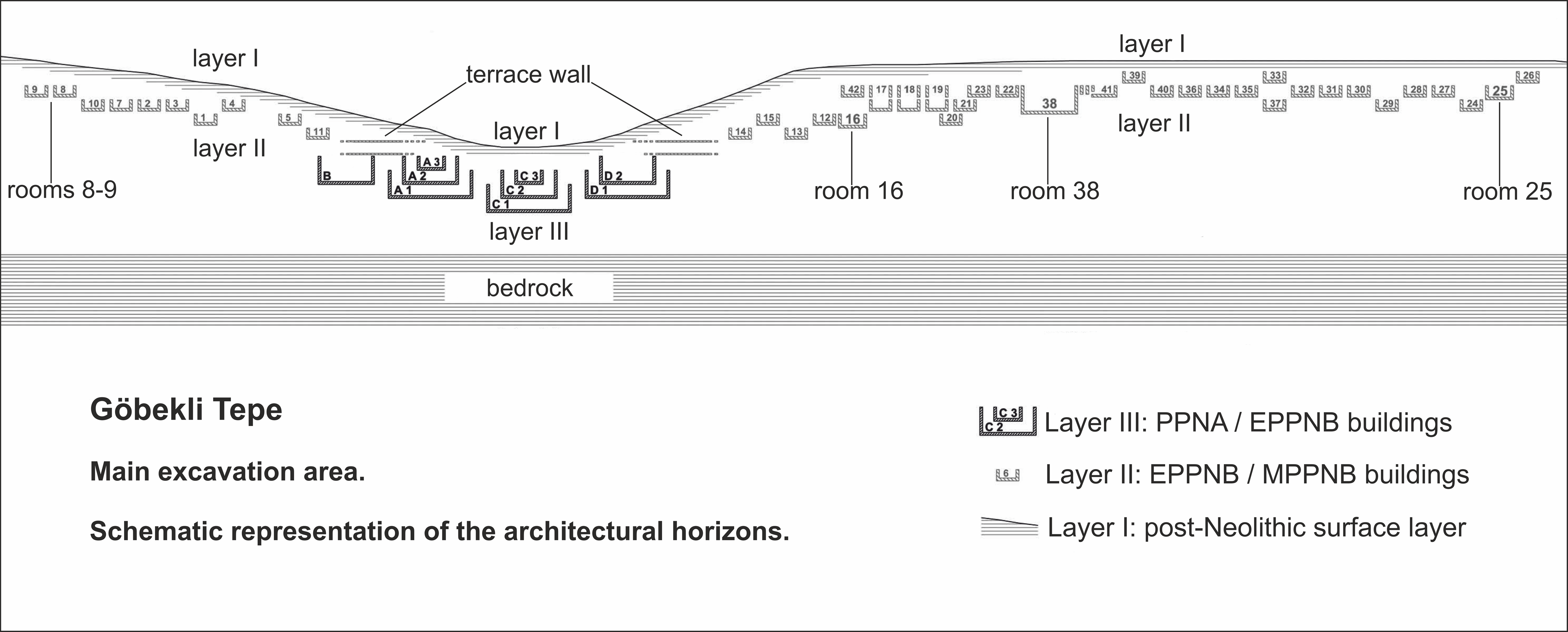
In its older phase the site was not a settlement with a few special buildings but a site made up exclusively of special buildings tied to Neolithic symbolic and religious life. Layer III consists of circles 10 to 30 m wide formed by monolithic T-shaped pillars that are linked by walls and benches, defining inner and outer spaces.
1. How old is the site, and how do we know?
Organic material in the loam wall plaster of Enclosure D gave 9984 ± 42 radiocarbon years BP, calibrated to 9745–9314 calBC and placing the circle in the PPNA. The single radiocarbon date for Enclosure C, from the outermost ring wall, is 9700 ± 30 BP, or 9261-9139 calBC at the 91.6 percent probability level.
Charcoal from deep soundings beside the Enclosure D ring wall clustered between 9664 and 9311 calBC, in good agreement with the plaster date from the same enclosure. Charcoal taken from beneath a fallen pillar fragment in Enclosure A dated a possible final filling event to around the mid-9th millennium calBC.
Radiocarbon on the architecture itself produced absolute ages that were clearly too young, pushing Layer III into the 9th millennium and Layer II into the 8th or even 7th millennia calBC. Pedogenic carbonate coats limestone as soon as it is buried, so dating the oldest carbonate layer in a thin section is intended to approach the moment of burial.
Because the refill happened quickly and without sterile water- or wind-lain layers, organic remains in the fill can be older or younger than the enclosures and can even produce an inverse stratigraphy. At the end of their use lives the Layer III enclosures were cleaned, partly dismantled and refilled, apparently in a relatively fast process that deposited valued objects in the filling.
Enclosure D has the earliest dates, documenting construction around the mid-10th millennium calBC, use, and burial in the late 10th millennium calBC. The radiocarbon series suggests the Layer III enclosures were not exactly contemporary, with the earliest dates from Enclosure D and Enclosure A apparently younger than C and D.
2. The enclosures and their pillars
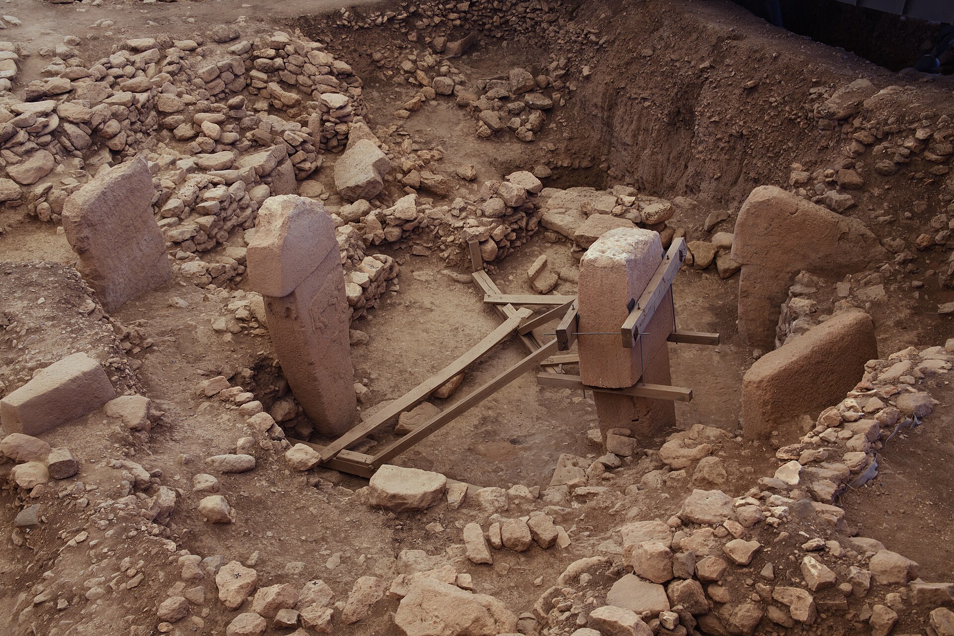
In the 10th-millennium BCE Layer III the ring pillars stand 3 to 5 m high and count between ten and twelve, while two taller central monoliths reach up to 5.5 m. Every enclosure's ring pillars are oriented towards a central pair of even larger pillars, and depictions of arms and hands mark those pillars as anthropomorphic.
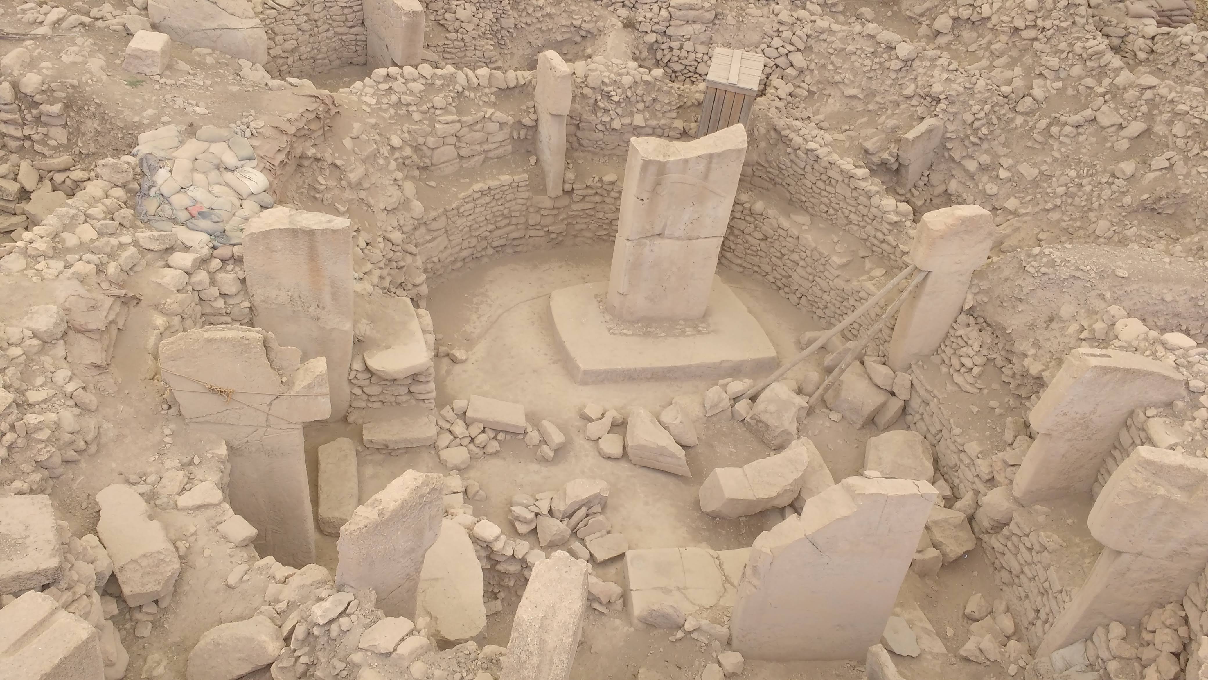
Many T-pillars show arms on their sides and hands clasped above the abdomen, so they have to be understood as monumental anthropomorphic sculptures. The pillar figures are always faceless with no eyes, nose or mouth, distinguished only by symbols below their heads, in the position where one would wear necklaces.
Only a few buildings, labelled A to H in order of discovery, have been excavated, while geophysical survey indicates at least twenty or so further buildings on the site. Geophysical survey located more than ten enclosures beyond the nine already under excavation, labelled A to I in order of discovery and spread across the plateau.
Among the traces of Neolithic quarrying is an unfinished T-pillar about 7 m long and 20 cubic metres in volume, while the central pillars of Enclosure D weigh 10 metric tons each. Prehistoric quarrying is visible as negative shapes in the bedrock, and a couple of unfinished, abandoned pillars still lie in situ where they were being cut.
3. Enclosure A: snakes
Pillar 1 of Enclosure A carries a central groove and bands decorated with five snakes in bas-relief, probably depicting a real stola-like garment. As in every building of the older layer, one animal dominates the imagery of Enclosure A, and here it is the snake.
Pillar 2 of Enclosure A bears a vertical sequence of a bull, a fox and a crane on its right side, and a bucranium between the bands of a stola-like garment on its back. Enclosure A appears more rectangular than round, and early radiocarbon data suggest it may be a little younger than Enclosures C and D.
Four ring pillars around the central pair of Enclosure A had been recorded when the overview was written, with more expected as excavation continues.
4. Enclosure B: foxes and dogs
Enclosure B is round with an internal diameter of nearly 10 m and two central pillars plus eight in the surrounding ring wall had been discovered. The two central pillars of Enclosure B, numbered nine and ten, carry a fox relief, the fox on the ninth measuring around 110 cm across its broad side.
Beneath the fox on Pillar 10 are shallow engravings of a boar and three dogs, probably a hunting scene added later. A terrazzo floor covering several square metres was exposed between the central pillars of Enclosure B, unlike most other PPNA enclosures whose floors are the smoothed natural bedrock.
A stone bowl was found embedded in the terrazzo floor in front of central Pillar 9 of Enclosure B.
5. Enclosure C and D
Each enclosure has its own dominant animal: snakes in Enclosure A, foxes in Enclosure B, boars in Enclosure C, birds in Enclosure D and wildcats in Enclosure H. The excavators suggest the differing dominant animals express different communities, possibly the different groups that built each enclosure.
6. Animals, symbols and human figures
Every animal shown at the site is wild, and much of the imagery is given to the most dangerous species and to scavenging birds of prey. Besides bulls, foxes and cranes, the pillars carry lions, ducks, scorpions, ants, spiders and snakes, and freestanding animal sculptures were found inside the circles.
Human figures are discreet in the imagery and become more common in later phases, in contrast to the overwhelming dominance of animals. Decoration of the 69 pillars known at the time follows regularities, being mostly animal motifs with abstract signs as well.
The life-size 'Urfa Man' was found during construction work at the nearby Pre-Pottery Neolithic site of Urfa-Yeni Yol and has obsidian-segment eyes but no mouth. Several limestone heads from Göbekli Tepe have a breaking edge at the neck showing they originally belonged to larger statues like Urfa Man.
In the 2008 season archaeologists uncovered a human statue plus sculptures of a vulture's head and a boar.
7. Temple, settlement, or neither?
The State Party itself set aside the "first temples of mankind" interpretation in its 2018 documents, preferring a broader concept of ancestor worship and raising the possibility of semi-permanent occupation. The researchers note that Schmidt himself flagged the problems of the temple label in his 2006 book, and that their own interpretation centres on gatherings and feasts.
Because the enclosures differ from contemporary settlement patterns and lack typical domestic material culture, the excavators call them communal or special-purpose buildings rather than temples. Almost every settlement of the period seems to have had at least one comparable communal building, but only at Göbekli Tepe is there a noticeable cumulation of the type.
Whether the enclosures were roofed is still debated, and no reliable proof of roof structures has been found, since any roofs must have been dismantled before backfilling. Porthole stones may not have been doorways at all: the enclosures could have been entered from above, and their design suggests exclusive use by a small group of ritual specialists.
8. The end: why was it abandoned and buried?
Neither domesticated plants nor domesticated animals occur at the site, so its abandonment around 8000 BC coincides with the fuller establishment of agriculture. Projectile points show use from the PPN A into the PPN B, but forms typical of the latest PPN B are missing, so the site was abandoned after the middle PPN B around 8000 BC.
The nomination dossier held that the Layer III enclosures were deliberately backfilled, with limestone rubble and flint flakes making up the fill, which also contained numerous probably feasting-related animal bones. Roughly 10,000 years under backfill preserved the stone walls and pillars, with slight damage only where archaeological material lay close to the surface.
There is ample evidence of revisiting and reworking existing enclosures: ongoing rearrangement, repair, depletion and re-use of pillars in other enclosures. Restriction of access to knowledge and to ritual participation seems attested: some object classes common in settlements are missing from the site.
9. Everyday life: food, water and labour
A study analysed more than 7000 grinding slabs, handstones, pestles and mortars and showed most were used to process cereals. Because no large storage facilities were identified, the authors argue food was produced for immediate consumption and the seasonal peaks reflect the organisation of large work feasts.
Experiment showed 500 g of einkorn ground in 40 to 60 minutes, and one handstone worked bidirectionally could produce about 4800 g of flour in eight hours, enough for five to ten people. Britannica notes that feeding and housing a large workforce may have made settlement a precondition of the monument rather than a consequence of it.
No springs are known near the site; the small seasonal Mucid Dere stream runs about 3 km to the west, and the nearest lakes lie some 5 km away. Cisterns on the western plateaus have a combined capacity of 153 cubic metres, which caps how many people could stay on site because rainwater was continuously available only in autumn and winter.
Even conservative estimates hold that building the monumental architecture at Göbekli Tepe and neighbouring sites needed a workforce of hundreds of people. Other estimates suggest as few as 7 to 14 people could move the pillars with ropes and lubricant.
Schmidt and colleagues estimated at least 500 people were needed to hew the 10- to 50-ton pillars from local quarries, move them from as far as a quarter-mile away, and erect them. Harald Hauptmann speculated that an elite class of religious leaders supervised the work and later controlled the rituals, which would be the oldest known evidence for a priestly caste.
10. Discovery and excavation
A survey by the universities of Istanbul and Chicago in 1963 first recognised the site, but the team misread the pillar tops as two small Islamic cemeteries, which discouraged further work. Schmidt, drawing on his experience at Nevalı Çori, recognised the 'tombstones' at Göbekli Tepe as Neolithic worked pieces and T-shaped pillars.
Excavation began in 1995 as a cooperative project of the Şanlıurfa Museum under Adnan Mısır and the Istanbul branch of the German Archaeological Institute under Harald Hauptmann. During the first season a landowner clearing stones had dug out two large T-shaped pillar heads and begun smashing one; he was persuaded to stop and excavation moved to that spot a year later.
Excavation showed that the tell is not made mainly of earth and loam: its sediments consist largely of limestone cobbles, bones and flints with relatively little earth.
11. World Heritage status and threats
Ownership of the property and its buffer zone is split between the state and private landowners, with the state owning 554 ha of the 587 ha total and all of the nominated parcels. In 2005 the tell and the limestone plateau were classed as a 1st Degree Archaeological Conservation Area by the Diyarbakır conservation council.
ICOMOS accepted criteria (i), (ii) and (iv) but judged the conditions of integrity and authenticity highly vulnerable to development projects and rising tourism. ICOMOS found that both the Adana-Şanlıurfa highway, 2.5 km away, and the irrigation channel 5 km from the site have a visual impact on the property.
Prehistoric activity ends after the PPNB; limestone was quarried again on the south-eastern plateau in the Roman era some 8,000 years later, and two later, probably Islamic, graves are the only other traces.
12. What the site changed in archaeology
Before Göbekli Tepe, archaeologists held that earliest monumental architecture was possible only after agriculture produced food surpluses, a theory the site turned on its head.
The sculptors may simply have depicted animals they saw, or made symbolic representations for rituals meant to ensure hunting success. Schmidt downplayed extravagant readings such as the idea, popular in the press, that the site inspired the Biblical Garden of Eden, while agreeing it was a sanctuary of profound significance.
13. The meaning of the pillars
Schmidt pointed out that the T-shaped pillars look like human bodies with a head in profile, and that they once stood on the hillside like a meeting of stone beings.
Schmidt believed the first stone circles marked the graves of important people and was reasonably confident that burials lie somewhere in the earliest layers of the site.
The arrangement of motifs on Pillar 2 of Enclosure A suggests it was moved to a secondary position, reversing its original front and back sides.
14. Where exactly is it, and how big is the property?
The site sits about 15 km north-east of modern Şanlıurfa and 2.5 km east of Örencik village, and the inscribed property itself covers 126 ha. The DAI project describes the tell as sitting about 15 km north-east of Şanlıurfa on the highest point of the Germuş range, 15 m high, about 9 ha in area and 300 m in diameter.
ICOMOS singles out the antiquity of the construction, roughly 12,000 years ago during the Neolithisation transition, and its monumental dimensions as the property's most significant characteristics.
15. Skulls, bones and the dead
Human burials are still absent, yet 691 human bone fragments have been recovered, 408 of them from skulls and 283 postcranial.
All three modified skulls belonged to adults aged between 20 and 50 years and the modifications include a drilled perforation, carvings, ochre on skull 1 and small cut marks.
Göbekli Tepe is the first site where carved skulls have been found; the carvings are deep, mainly sagittally oriented grooves made by repeated cutting. The three modified skulls form an entirely new category of find that testifies to interaction between the living and the dead at this early Neolithic ritual centre.
Forty skull fragments, 9.8 percent of the skull material, carry cut marks attributed to defleshing. The three modified skulls correspond to 15 percent of the identified adult individuals at the site, based on the minimum number of individuals.
The monuments were probably tied to rituals, most likely of a funerary character, according to the World Heritage listing description.
16. Layer II: what came after the big circles
In the later Layer II of the 9th millennium BCE the rooms become smaller and usually rectangular, with terrazzo floors and fewer, lower T-shaped pillars. Layer II is characterised by smaller rectangular buildings about 3 by 4 m with terrazzo floors, which may be understood as minimised versions of the older enclosures sharing the T-shaped pillar.
In the Layer II rooms the pillars shrink, the largest not exceeding 2 m and some rooms having none, yet no domestic traces such as hearths or ovens had then been detected.
The monumental round-oval buildings are about 20 m across with richly decorated pillars up to 5.5 m high, while the later rectangular buildings are smaller with pillars up to 2 m.
While some Layer II buildings are domestic, domestic architecture contemporary with the oldest phases of the monumental buildings has not been identified. The oldest structures belong to the early PPNA ending about 9000 BC, and the later PPNB remains of about 8000 BC are notably less elaborate, with most T-pillars and animal sculptures in the earliest levels.
17. What the stones still hide
A system of channels and cisterns is documented on the limestone plateau, though it is not certain that these features are contemporary with the Neolithic architecture.
Constant rebuilding and repair, and the apparent emptying of the buildings before backfilling, make it impossible to date their abandonment precisely.
A dated buried humus layer in area L9-68 marks the last PPN activity in that area and gives a terminus ante quem for Layer II, calibrating to the late ninth or early eighth millennium BC.
18. Timeline
- c. 9500 BCE (later 10th millennium)The first enclosures go upIn the second half of the 10th millennium BCE, within the PPNA, the first versions of enclosures A to D and round-oval domestic structures are built on the plateau, indicating a semi-sedentary way of life.
- 9500–8000 BCEOccupation of the tellThe site is inhabited from around 9500 BCE to at least 8000 BCE, spanning the Pre-Pottery Neolithic A and B.
- Early 9th millennium BCEWalls rebuilt with the first monolithic pillarsEnclosures A to D are substantially modified: new walls are raised that incorporate the first monolithic T-shaped pillars, and domestic structures grow more rectangular.
- Late 10th to early 9th millenniumEnclosure D fills with debrisA severe slope slide inundates Enclosure D with rubble from domestic structures and sediments; a second slide probably causes its abandonment in the late 9th millennium BCE.
- About 8000 BCEAbandonmentTypical latest-PPNB projectile points are missing, so the site appears to have been abandoned after the middle PPNB, around 8000 BC.
- Middle 3rd millennium BCELater visitorsAfter the Neolithic ends, smaller groups return to live among the ruins; quarrying on the south-eastern plateau resumes in the Roman era, some 8,000 years later.
- 1963Surveyed and misreadA survey by the universities of Istanbul and Chicago recognises the site as prehistoric but interprets the pillar tops as two small Islamic cemeteries.
- October 1994Schmidt recognises the pillarsKlaus Schmidt, drawing on his work at Nevalı Çori, identifies the 'tombstones' at Göbekli Tepe as Neolithic T-shaped pillars.
- 1995Excavation beginsDigging starts as a cooperation between the Şanlıurfa Museum and the Istanbul branch of the German Archaeological Institute, with a first trench on the south-eastern slope.
- 1996Enclosure A uncoveredWork begins on the area a landowner had started to clear, exposing the first monumental enclosure of the older layer after two pillar heads had already been dug out.
- 2014Schmidt diesKlaus Schmidt dies in 2014; research continues as a project of the DAI, Istanbul University and the Şanlıurfa Museum, with excavation permits granted to the museum.
- June 2017Carved skulls publishedResearch in Science Advances reports three artificially modified human skulls from the site, interpreted as evidence of a previously undocumented form of skull cult.
- 1 July 2018World Heritage inscriptionGöbekli Tepe is inscribed on the UNESCO World Heritage List at the 42nd session in Manama, Bahrain, on criteria (i), (ii) and (iv).
- 2019Cereal study and a revisionA study of more than 7000 grinding artifacts shows intensive cereal processing tied to the rectangular buildings and interpreted as evidence for work feasts.
- 2020The temple narrative challengedThe project's own research summary sets aside the intentional-backfill reading in favour of slope slides and abandons Schmidt's tripartite chronological scheme.
- 2021About a tenth excavatedAround 10 percent of the site has been excavated, while geophysical survey shows the mound contains at least 20 large enclosures.
19. Frequently asked questions
How much of Göbekli Tepe has actually been excavated?
About 10 percent of the site had been excavated as of 2021 14Göbekli Tepe · Wikipedia ↗. Only a few buildings, labelled A to H in order of discovery, have been excavated, while geophysical survey indicates at least twenty or so further buildings on the site 5Göbekli Tepe — ICOMOS Advisory Body Evaluation, 42nd session (2018) · ICOMOS / UNESCO World Heritage Centre ↗.
What did the 1963 survey team think the site was?
Chicago and Istanbul anthropologists visited the hill in the 1960s and, seeing broken limestone slabs, assumed the mound was an abandoned medieval cemetery 16Gobekli Tepe: The World’s First Temple? (Andrew Curry) · Smithsonian Magazine ↗.
Were the enclosures roofed, and how were they entered?
Whether the enclosures were roofed is still debated, and no reliable proof of roof structures has been found, since any roofs must have been dismantled before backfilling 12Ask an archaeologist (about Göbekli Tepe) · The Tepe Telegrams, Göbekli Tepe Research Project (DAI) ↗.
What was found in the fill of the enclosures?
The nomination dossier held that the Layer III enclosures were deliberately backfilled, with limestone rubble and flint flakes making up the fill, which also contained numerous probably feasting-related animal bones 5.
What happened at the site after the Neolithic?
Prehistoric activity ends after the PPNB; limestone was quarried again on the south-eastern plateau in the Roman era some 8,000 years later, and two later, probably Islamic, graves are the only other traces 5.
How many people were needed to build the monuments?
Even conservative estimates hold that building the monumental architecture at Göbekli Tepe and neighbouring sites needed a workforce of hundreds of people 11Cereal processing at Early Neolithic Göbekli Tepe, southeastern Turkey (PLoS ONE 14(5): e0215214) · PLOS ONE ↗. Other estimates suggest as few as 7 to 14 people could move the pillars with ropes and lubricant 14.
References (16)
- 1Göbekli Tepe (World Heritage List, ref. 1572) — UNESCO World Heritage Centre 1572 WebView source
- 2Göbekli Tepe – The first 20 Years of Research — The Tepe Telegrams, Göbekli Tepe Research Project (DAI) 2016 WebView source
- 3Cooperative Action of Hunter-Gatherers in the Early Neolithic Near East. A View from Göbekli Tepe — The Tepe Telegrams, Göbekli Tepe Research Project (DAI) WebView source
- 4How old is it? Dating Göbekli Tepe — The Tepe Telegrams, Göbekli Tepe Research Project (DAI) 2016 WebView source
- 5Göbekli Tepe — ICOMOS Advisory Body Evaluation, 42nd session (2018) — ICOMOS / UNESCO World Heritage Centre 2018 Web↩View source
- 6Could we really call it a ‘temple’? — The Tepe Telegrams, Göbekli Tepe Research Project (DAI) 2016 WebView source
- 7Enclosure A, a short overview — The Tepe Telegrams, Göbekli Tepe Research Project (DAI) 2017 WebView source
- 8Enclosure B, a short overview — The Tepe Telegrams, Göbekli Tepe Research Project (DAI) 2017 WebView source
- 9Cooperative Action of Hunter-Gatherers in the Early Neolithic Near East — A View from Göbekli Tepe — The Tepe Telegrams, Göbekli Tepe Research Project (DAI) 2017 WebView source
- 10The World’s First Temple (Sandra Scham, vol. 61 no. 6) — Archaeology Magazine WebView source
- 11Cereal processing at Early Neolithic Göbekli Tepe, southeastern Turkey (PLoS ONE 14(5): e0215214) — PLOS ONE Journal↩View source
- 12Ask an archaeologist (about Göbekli Tepe) — The Tepe Telegrams, Göbekli Tepe Research Project (DAI) 2017 Web↩View source
- 13Göbekli Tepe — Encyclopaedia Britannica WebView source
- 14Göbekli Tepe — Wikipedia Web↩View source
- 15Modified human crania from Göbekli Tepe provide evidence for a new form of Neolithic skull cult (Science Advances 3(6): e1700564) — Science Advances — PMC full text WebView source
- 16Gobekli Tepe: The World’s First Temple? (Andrew Curry) — Smithsonian Magazine Web↩View source