Machu Picchu
The Inka citadel on the ridge above the Urubamba — how it was built without mortar or the wheel, what the radiocarbon dates and the chronicles say about its age, and how Bingham, Yale and Peru wrote its modern story.
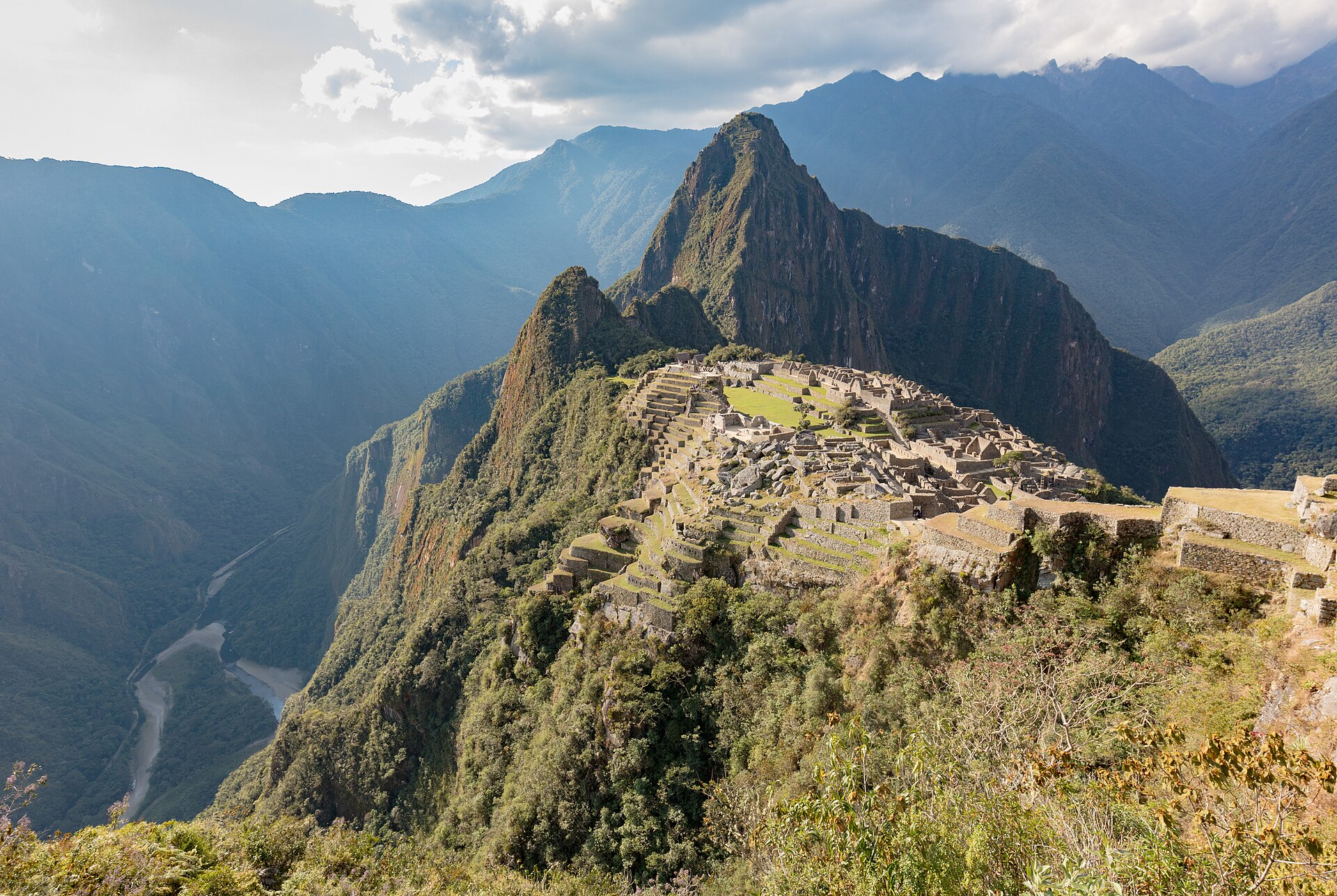
Machu Picchu is the most famous and best-preserved city of the Inka Empire: roughly 200 buildings, temples, terraces and fountains fitted together without mortar on a granite saddle 2,430 metres above the sea, between the peak of Machu Picchu and Huayna Picchu. Built around AD 1450 as a royal estate attributed to the Inka Pachakuti, it was abandoned in the sixteenth century and hidden by cloud forest until Hiram Bingham reached it on 24 July 1911. Since then it has become a UNESCO World Heritage site (1983), one of the New Seven Wonders of the World (2007), the subject of a century-long dispute over the artifacts Bingham removed, and a laboratory for engineers and archaeologists studying Inka drainage, masonry and land use. This fact file gathers the evidence from UNESCO's World Heritage records, Peru's Ministry of Culture and the National Archaeological Park of Machu Picchu, Yale University, National Geographic, Britannica, Hiram Bingham's own 'Inca Land' and 1913 expedition report, and peer-reviewed research in Radiocarbon, Scientific Reports, NHESS and the Journal of Irrigation and Drainage Engineering.
A city above the clouds
Machu Picchu stands 2,430 metres above sea level, in the middle of a tropical mountain forest on the eastern slopes of the Andes.1 UNESCO calls the citadel probably the most amazing urban creation of the Inka Empire at its height, its giant walls, terraces and ramps seeming to have been cut naturally into the continuous rock escarpments.1 The city lies about 80 km northwest of Cuzco, perched above the Urubamba River valley in a narrow saddle between two sharp peaks — Machu Picchu, the 'Old Peak', and Huayna Picchu, the 'New Peak'.2 Britannica places the saddle at 7,710 feet, or 2,350 metres.2 The name is Quechua: machu means 'old' and picchu means 'peak', so the toponym is a direct reference to the mountain relief on which the archaeological monument sits.3
The Historic Sanctuary — National Archaeological Park of Machupicchu covers 37,302 hectares, is one of the most biodiverse areas of Peru, and holds more than 60 archaeological monuments linked by a complex network of Inka roads.4 The mixed World Heritage property covers 32,592 hectares of mountain slopes, peaks and valleys surrounding its heart, the citadel, at more than 2,400 metres above sea level.1 Some 200 structures — a religious, ceremonial, astronomical and agricultural centre — are set on a steep ridge crisscrossed by stone terraces.1 Under Criterion (i), the Inka city is described as the articulating centre of its surroundings — a masterpiece of art, urbanism, architecture and engineering of the Inka civilization.1 UNESCO ranks the sanctuary among the greatest artistic, architectural and land-use achievements anywhere and the most significant tangible legacy of the Inka civilization.1
What was Machu Picchu for?
Research by John Rowe, Richard Burger and Lucy Salazar-Burger indicates that rather than a defensive stronghold, Machu Picchu was a retreat built by and for the Inka ruler Pachacuti.5 Burger has suggested that it was built for elites wanting to escape the noise and congestion of Cusco.5 Machu Picchu and the surrounding areas constituted a private royal holding attributed to Pachacuti Inka Yupanqui.6 The construction style and other evidence suggest a palace complex of the ruler, and the dwellings were probably built and occupied from the mid-fifteenth to the early or mid-sixteenth century.2 By Inka standards the city was relatively small: it maintained only about 500 to 750 people.5 The Peruvian expert Luis Lumbreras describes a citadel made up of palaces and temples, dwellings and storehouses, a site fulfilling ceremonial religious functions.5
One sector is cordoned off by walls, ditches and perhaps a moat — read by Lumbreras not as part of a military fortification but as a form of restricted ceremonial isolation.5 Bingham, working from the several dozen skeletons excavated in 1912, most of them initially identified as female, suggested that the site was a sanctuary for the Virgins of the Sun, the elite group known as the Chosen Women.2 Modern studies have shown a more reasonable fifty-fifty split between male and female bones, overturning that reading.5 Varying kinds of head modelling and ceramics crafted by many peoples, some from as far away as Lake Titicaca, suggest that the inhabitants came from different parts of the empire.5 The reason for the site's abandonment is unknown, but lack of water may have been a factor.2 Many of Machu Picchu's mysteries remain unresolved, including the exact role it may have played in Inka astronomy and in the domestication of wild plant species.1
A sacred landscape between the Andes and the Amazon
Johan Reinhard, a National Geographic explorer-in-residence who spent years studying ceremonial Inka sites at extreme altitudes, argues that Machu Picchu was built in the centre of a sacred landscape.5 The city is nearly surrounded by the Urubamba River, which is still revered by people of the region, and the mountains that cradle the site are important sacred landforms.5 Taken together, Reinhard says, these features meant that Machu Picchu formed a cosmological, hydrological and sacred geographical centre for a vast region.5 The sanctuary sits at the meeting point between the Peruvian Andes and the Amazon Basin.1 UNESCO finds that the property meets the conditions of integrity: the natural and human-made attributes and values that sustain its Outstanding Universal Value are mostly contained within its boundaries, and the visual ensemble linking the archaeological site with its striking mountain environment remains mostly intact.1 Upon the abandonment at the beginning of the sixteenth century, vegetation growth and isolation ensured the conservation of the architectural attributes of the property.1
The water engineers of the Urubamba
Geophysical research describes the Inka site as sitting on an earthquake fault over an inaccessible mountain, with steep slopes, landslides and abundant rainfall — conditions that posed critical drainage challenges, met successfully by the Inka through advanced engineering techniques that are still not fully understood.7 The nearly 2,000 mm of rain a year, the steep slopes, the landslides and the inaccessibility formed the difficult site constraints that the Inka successfully answered.8 Civil engineers describe the drainage infrastructure constructed by the Inka at Machu Picchu as a significant public works achievement.8 Proof of the Inka success with drainage rests with the fact that Machu Picchu lay in the rainforest for 400 years without failure.8 The system remains in use today and is effective in preventing water logging, soil erosion and the collapse of walls.7
Geophysical and archaeological analysis indicates that around 60% of the construction effort at Machu Picchu was needed to reshape the water catchment for the drainage system.7 Peru's Ministry of Culture reckons that more than 50% of the effort required to build the llaqta was employed in preparing the terrain, the foundations and the drainage system.4 The first transformation of the site was quarrying that reshaped the natural drainage basin, using material drawn from rock dispersed by erosion between the peaks.7 The 700-plus preserved terraces held soil, promoted agriculture and served as part of an extensive water-distribution system that conserved water and limited erosion on the steep slopes.9 Down the city's main stairway runs a series of 14 or 15 fountains, sometimes cut from a single granite slab, with holes drilled so that water flowed through carefully cut underground channels to the next basin below.10
Architecture: what to see at the citadel
The stones were fashioned without mortar and fitted so tightly that not even a knife's blade could be inserted between them.5 Entering the ruins, Bingham suddenly found himself in a maze of beautiful granite houses, hidden in bamboo thickets and tangled vines and covered with the growth of centuries.11 Two of the structures he found were among the finest he had ever seen in Peru, with ashlars of Cyclopean size ten feet in length and higher than a man.11 When Machu Picchu was built the Inka had no iron, no steel and no wheels.9
| Structure | Where it is | What to look for |
|---|---|---|
| Temple of the Sun and Sacred Rock | Southern part of the ruin; Bingham called it the Mausoleum, and the horseshoe-shaped Military Tower rises above the rock.2 | Semicircular construction around a large boulder; at the summer solstice the sun shines through a temple window and aligns with both the boulder within and the tip of a nearby mountain peak.9 |
| Temple of the Three Windows | A hall 35 feet (10.6 m) long and 14 feet (4.2 m) wide, on one wall built of polygonal stones.2 | Three trapezoidal windows — the largest known in Inka architecture.2 |
| Intihuatana | Near the Main Plaza.2 | The Hitching Post of the Sun, a wide pillar and pedestal carved as a single unit and standing 6 feet (1.8 m) tall; damaged in 2000 during the filming of a beer commercial.2 |
| Sacred Plaza | The site of two of the finest structures at Machu Picchu.10 | A remarkable structure about 12 feet in height, built around three sides of a rectangle some 30 feet long and 18 feet wide, using tremendous blocks of granite, three of them over 12 feet in length.10 |
| Main Plaza and formal entrance | The plaza lies at the north-central end of the site, partly divided by wide terraces.2 | At the southeastern end is the only formal entrance, which leads to the Inka Trail.2 |
| Fountain stairway | The city's main stairway.10 | A series of 14 or 15 fountains; each basin about 2½ feet long by 1½ feet wide and 5 to 6 inches deep, with holes drilled to let water flow through underground channels to the next basin below.10 |
| Princess's Palace and Palace of the Inka | The Princess's Palace is a bi-level structure of highly crafted stonework that probably housed a member of the Inka nobility.2 | The Palace of the Inka is a complex of rooms with niched walls and a courtyard.2 |
| Huayna Picchu summit | The peak that overshadows the city like a sentinel.10 | Rough caves found on the summit, whence guards could give warning of approaching danger.10 |
The principal temple was lined with exquisitely made niches — five high up at each end and seven on the back wall — with a rectangular block fourteen feet long beneath the rear niches, probably a sacrificial altar.11 The tremendous effort apparently benefited relatively few people; some experts maintain that fewer than a thousand individuals lived there.9
Dating the city: chronicles versus radiocarbon
In the classical chronology of the Inka state, Pachacuti came to power around AD 1438 and the construction of Machu Picchu began by AD 1450-1460.6 Peru's Ministry of Culture dates the planning and construction of the Inka city of Machupicchu to around AD 1450, during the government of the Inka Pachakuti.4 Historically it was estimated that construction began about ten years after the start of Pachacuti's reign, that is around AD 1450.6 A study of 11 new AMS radiocarbon dates, modelled with Bayesian statistics, gives a 68.2% probability that the first dated activity at the Llaqta of Machu Picchu falls between cal AD 1422 and 1448 — earlier than the traditional date.6 That modelling also suggests the Llaqta may have been preceded by other Inka installations in the area, specifically the site of Choqesuysuy.6
The radiocarbon programme considered not only the main site but also its 60 satellite sites.6 One of them, Chachabamba, is a ceremonial complex related to a water shrine and includes 14 ceremonial baths.6 Machu Picchu and its surroundings constituted a private royal holding attributed to Pachacuti Inka Yupanqui.6 The dwellings were probably built and occupied from the mid-fifteenth to the early or mid-sixteenth century, and the construction style suggests a palace complex of the ruler Pachacuti.2 Built in the fifteenth century, Machu Picchu was abandoned when the Inka Empire was conquered by the Spaniards in the sixteenth, and it was not until 1911 that the archaeological complex was made known to the outside world.1 Engineers conclude that the effective abandonment came about AD 1540, after which the site endured four and a half centuries under a thick rainforest.8
Discovery: Bingham and the lost-city myth
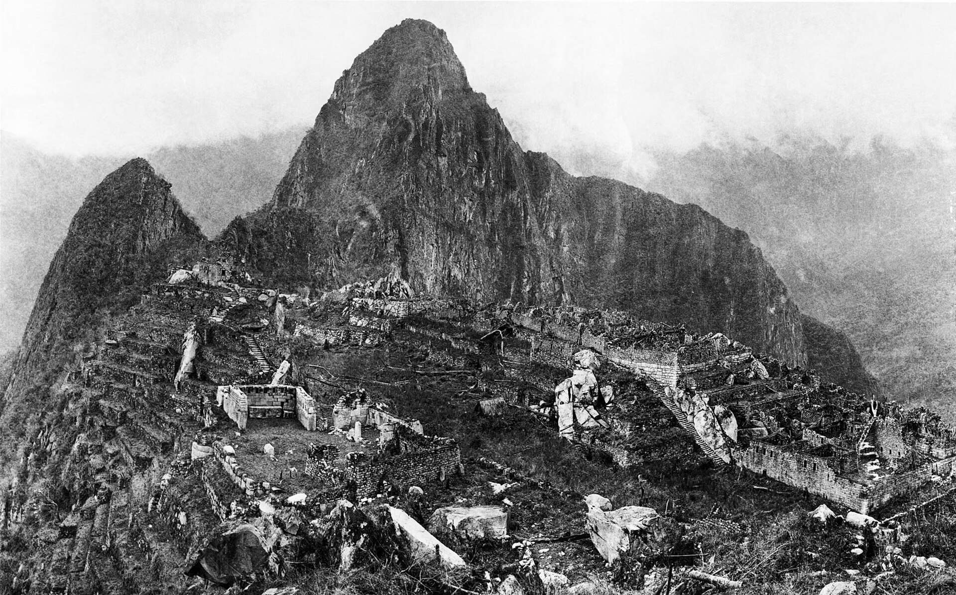
The morning of 24 July 1911 dawned in a cold drizzle, and the farmer Arteaga only agreed to guide the way once he was offered a sol — three or four times the ordinary daily wage in the vicinity.11 Two farmers, Richarte and Alvarez, had chosen the eagle's nest for their home, finding plenty of terraces on which to grow their crops and keeping free of undesirable visitors.11 With a small boy leading the way, Bingham stumbled upon one of the greatest archaeological finds of the 20th century — and what was named in 2007 as one of the new seven wonders of the world.5 Although the site escaped detection by Spanish explorers, it may have been visited by the German adventurer Augusto Berns in 1867.2
Bingham's discovery was published in the April 1913 issue of National Geographic magazine, bringing the mountaintop citadel to the world's attention.5 The National Geographic Society helped fund his excursions to Machu Picchu in 1912 and 1915.5 National Geographic's editor Gilbert Grosvenor saluted the builders, who constructed the wonderful city of refuge on the mountain top without steel implements, using only stone hammers and wedges.10 The expedition's surveyor produced a map of Machu Picchu, the result of three months' work, on a scale of 1 inch = 20 feet with a 10-foot contour interval, in 16 large sheets.10 Bingham believed he had found Vilcabamba, the last independent Inka capital; it was Gene Savoy's work at Espiritu Pampa in 1964 that showed the lost city lay elsewhere.5

Peru takes charge: law, restoration and research
Peruvian Law 6634 of 13 June 1929 declared archaeological monuments to be state property — intangible, imprescriptible and inalienable — and expressly listed Machupicchu among the principal national monuments.3 After the Cusco earthquake of 21 May 1950, the CRYF was created to take charge of the cleaning, restoration, exploration and study of the monument.3 A Machupicchu Restoration Commission was then active from 1950 to 1968.3
Beyond Bingham's 1915 campaign, the site was further excavated in 1934 by the Peruvian archaeologist Luis Valcarcel and in 1940-41 by Paul Fejos.2 The Management Unit of the Historic Sanctuary of Machu Picchu, known as the UGM, was established in 1999 to lead the strategies contained in the Master Plans, the regularly updated governing documents for the property.1 It was reactivated in 2011 with representatives of the ministries of Culture, Environment and Foreign Trade and Tourism, the Regional Government of Cusco and the local municipality.1 The technical and legal management documents maintained by the Ministry of Culture and the park today include ministerial resolutions of 2023-2024 and the Master Plan of the Historic Sanctuary, allowing integrated management and conservation of the property.12
World Heritage and the pressures of fame
In 1983 the Historic Sanctuary of Machu Picchu was inscribed on the World Heritage List as a mixed cultural and natural property under criteria (i)(iii)(vii)(ix).1 Machu Picchu is the most economically important tourist attraction in Peru, bringing in visitors from around the world.2 Tourism represents a double-edged sword, providing economic benefits but also resulting in major cultural and ecological impacts; the strongly increasing number of visitors must be matched by adequate management regulating access and diversifying the offer.1 Since the time of inscription, consistent concerns have been expressed about ecosystem degradation through logging, firewood and commercial plant collection, poor waste management, poaching, agricultural encroachment, introduced species and water pollution in the Urubamba River.1 The gateway town serves the more than 700,000 tourists who visit annually, has grown threefold in population in two decades, and is pushing construction onto unstable valley slopes.13
Between 6 and 11 September 1997 a large brush fire consumed over 800 hectares of mountain forest around the World Heritage site, and more than 400 firefighters pumped water on the dense vegetation until torrential rains ended the five-day fire; the site reopened on 12 September.14 On 25 January 2010 landslides blocked the railway between Aguas Calientes and Ollantaytambo and stranded 2,000 tourists near the sanctuary, until helicopters began their rescue.15 The citadel itself was not impacted by the heavy rainfall, though the area it occupies represents only a small percentage of the total protected area.15 The World Heritage Committee, at its 33rd session in Seville in June 2009, recommended the implementation of a risk management plan, a public use plan, urban planning, transportation systems, controlled visitor access points and measures to reduce the risk of landslides.15 A prototype early warning system that could monitor weather, river flow and slope stability was installed along the Aguas Calientes River in 2009, proving that it is technically feasible to develop early warning capacity in the town.13
The artifacts come home
Yale University and the Government of Peru reached a historic accord in November 2010 for the return to Peru of the archaeological materials excavated by Hiram Bingham III at Machu Picchu nearly a century earlier.16 In February 2011, Yale and UNSAAC signed an agreement establishing the UNSAAC-Yale International Center for the Study of Machu Picchu and Inka Culture in Cusco.16 The center is dedicated to the display, conservation and study of the Machu Picchu archaeological collections curated by Yale at the Peabody Museum since their excavation by Bingham in 1912.16 Yale began sending its collection of artifacts to Peru in March 2011; the initial shipment included intact objects suitable for museum display along with pottery fragments and other materials, and meant that the artifacts would be in Peru for the July 2011 centennial anniversary of the discovery.16 Following that shipment, the remaining collections were transported to Peru in December 2011 and November 2012.16 Yale officials attended the opening ceremony for the new center in Cusco in October 2011, and the Museo Machu Picchu in the Casa Concha, a historic Inka palace, has been a tremendous success with the people of Cuzco, for whom admission is free.16
Visiting Machu Picchu
Below the ruins, the town of Machu Picchu serves the more than 700,000 tourists who visit the citadel each year.13 The section of the Inka Trail from the 'km 88' train stop to Machu Picchu is normally hiked in three to six days.2 It is composed of several thousand stone-cut steps, numerous high retaining walls and tunnels, and traverses a wide range of elevations between about 2,600 and 4,200 metres.2
In Bingham's words
In his book Inca Land, Bingham's account of finding the ruins remains one of the most vivid descriptions of the city.11 The 1913 report carried a salute to the builders from the magazine's editor, Gilbert Grosvenor.10
Crossing these terraces, I entered the untouched forest beyond, and suddenly found myself in a maze of beautiful granite houses!
Hiram Bingham, Inca Land (1922)
could be seen, here and there, walls of white granite ashlars most carefully cut and exquisitely fitted together.
Hiram Bingham, Inca Land (1922)
The sight held me spellbound.
Hiram Bingham, Inca Land (1922)
What an extraordinary people the builders of Machu Picchu must have been to have constructed, without steel implements, and using only stone hammers and wedges, the wonderful city of refuge on the mountain top.
Gilbert Grosvenor, Editor, National Geographic Magazine, April 1913
Running through both voices is the same astonishment: a people with no iron, no steel and no wheels built a city of close-fitting granite on a mountain ridge.9
Timeline
Pachacuti takes power in the traditional chronology
According to the classical chronology of the Inka State, Pachacuti Inca Yupanqui, ninth sovereign, ascends to power around AD 1438 — the framework on which the dating of Machu Picchu has long rested.
Earliest radiocarbon evidence of Inka activity at the site
AMS radiocarbon dates from the 2017 excavations, modelled with Bayesian statistics, give a 68.2% probability that first activity at the Llaqta of Machu Picchu began between cal AD 1422 and 1448.
The llaqta is planned and built under Pachakuti
Peru's Ministry of Culture states that the Inka city of Machupicchu was planned and built around AD 1450, during the government of the Inka Pachakuti, as a religious, political and administrative centre in a sacred Andean-Amazonian landscape.
The city is abandoned
Engineers studying its waterworks conclude Machu Picchu was essentially abandoned about AD 1540, after the arrival of the Spanish conquistadors; Peru's Ministry of Culture places the abandonment in the second half of the 16th century.
The name 'Machu Picchu' first appears on a map
The engineer Herman Göhring produces a cartographic document that, for the first time, records the toponyms 'Machu Picchu' and 'Huaina Picchu'.
Hiram Bingham reaches the ruins
On a cold, drizzly morning the Yale lecturer Hiram Bingham, guided by the farmer Melchor Arteaga and led onward by a small boy, climbs to the forested citadel — bringing Machu Picchu to the world's attention.
The Yale-Peru expedition clears, maps and excavates
A multidisciplinary expedition sponsored by Yale University and the National Geographic Society clears vegetation, excavates and surveys the site; a three-month survey produces a large-scale map in 16 sheets.
National Geographic magazine publishes Bingham's report
Bingham's discovery is published in the April 1913 issue of National Geographic, with some 250 photographs, bringing the mountaintop citadel to a mass readership.
Peruvian-led excavations: Valcarcel and Fejos
After Bingham's 1915 campaign, Machu Picchu is further excavated in 1934 by the Peruvian archaeologist Luis E. Valcarcel and in 1940-41 by Paul Fejos, beginning the long Peruvian stewardship of the site.
Espiritu Pampa proves to be the 'lost city'
Gene Savoy identifies and extensively excavates Espiritu Pampa, showing that the last independent Inka capital, Vilcabamba — which Bingham thought was Machu Picchu — lies elsewhere.
UNESCO World Heritage inscription
The Historic Sanctuary of Machu Picchu is inscribed on the World Heritage List as a mixed cultural and natural property under criteria (i)(iii)(vii)(ix).
A brush fire threatens the ruins
A large brush fire burns over 800 hectares of mountain forest around the World Heritage site; more than 400 firefighters pump water on the hillsides until torrential rain ends the five-day fire, and the site reopens on 12 September.
The Intihuatana is damaged during filming
The carved stone that Bingham called the 'sun dial stone' is damaged when a film crew for a beer commercial strikes it — an incident that fuels Peruvian demands for tighter protection of the monument.
Voted one of the New Seven Wonders of the World
A worldwide poll names Machu Picchu one of the new seven wonders of the world — a mixed blessing for Cusco, bringing pride and revenue along with pollution and construction pressure.
Floods and landslides cut off the sanctuary
Torrential rains bring landslides that block the railway; 2,000 tourists are stranded near the sanctuary, one tourist and one guide die, and UNESCO later sends a technical mission to assess risks to the core zone.
The artifacts come home
Following a November 2010 accord, Yale ships its Machu Picchu collection to Peru in three transfers (March and December 2011, November 2012); the UNSAAC-Yale museum opens in Cusco's Casa Concha in October 2011, in time for the July 2011 centennial of Bingham's discovery.
Frequently asked questions
Where is Machu Picchu and how high does it stand?
It stands 2,430 metres above sea level, in the middle of a tropical mountain forest on the eastern slopes of the Andes.1 The city lies about 80 km northwest of Cuzco, perched above the Urubamba River valley, at 7,710 feet or 2,350 metres.2
When was Machu Picchu built?
Peru's Ministry of Culture states that the Inka city of Machupicchu was planned and built around AD 1450, during the government of the Inka Pachakuti.4 AMS radiocarbon dates modelled with Bayesian statistics give a 68.2% probability that first activity at the Llaqta falls between cal AD 1422 and 1448.6
Was Machu Picchu ever really lost?
It was abandoned during the second half of the sixteenth century, but was never really lost: it was visited and occasionally inhabited, and colonial documents already called it the 'Asiento de los Incas'.4 The toponyms Machu Picchu and Huaina Picchu had already been recorded by the engineer Herman Göhring in 1874.4
Why was Machu Picchu abandoned?
The reason for the site's abandonment is unknown, but lack of water may have been a factor.2 Engineers conclude that the effective abandonment came about AD 1540, after which the site lay for four and a half centuries under thick rainforest.8
How were the walls built without mortar?
The stones were fashioned without mortar and fit so tightly that not even a knife's blade could fit between them.5 When the city was built the Inka had no iron, no steel and no wheels.9
Where are the artifacts Bingham took to Yale?
They were curated by Yale at the Peabody Museum since their excavation in 1912, and returned to Peru following a November 2010 accord, in three shipments between March 2011 and November 2012.16 They are displayed at the Museo Machu Picchu in Cusco's Casa Concha, a historic Inka palace.16
Is Machu Picchu a World Heritage site?
Yes — it was inscribed in 1983 as a mixed cultural and natural property under criteria (i)(iii)(vii)(ix).1 It was named one of the new seven wonders of the world in a worldwide poll in 2007.5
How long does the Inka Trail take?
The portion of the trail from the 'km 88' train stop to Machu Picchu is normally hiked in three to six days, over several thousand stone-cut steps and a range of elevations between about 2,600 and 4,200 metres.2
Knowledge graph
Sources & citations
Every factual claim in this article is drawn from the sources below. Bracketed numbers in the text link to the corresponding source.
- 1
- 2
- 3
- 4
- 5
- 6
- 7
- 8
- 9
- 10
- 11
- 12
- 13
- 14
- 15
- 16