The Sahara
The world's largest hot desert — dunes, rock art, and deep time, from the Green Sahara of the African Humid Period to the dust that crosses the Atlantic.
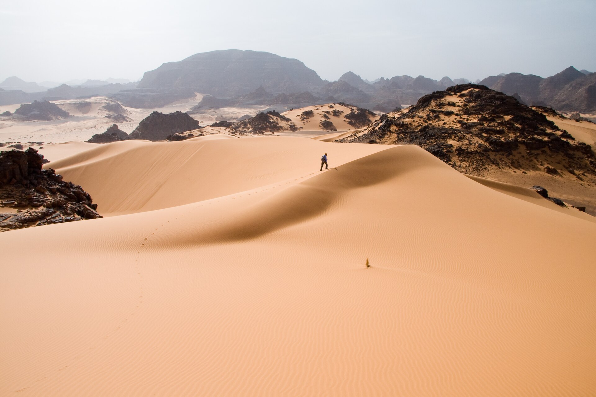
The Sahara is the largest hot desert on Earth, filling nearly all of northern Africa from the Atlantic coast to the Red Sea. Britannica gives it a total area of some 3,320,000 square miles (8,600,000 square km) — but the figure depends on how the desert boundary is drawn: an analysis of twentieth-century rainfall puts the climatological Sahara at 7,426,000 square km, while other reviews cite about 9.2 million square km. Some 2.5 million people live in the desert itself, in oases and along its margins — Tuareg, Teda, Chaamba and other communities whose camel caravans once linked the Mediterranean world to Timbuktu. Between about 14,800 and 5,500 years ago much of the Sahara was green, a landscape of rivers, lakes and savanna known as the African Humid Period; the rock art of Tassili n'Ajjer and the Ennedi Massif still records elephants, giraffes and hippopotamuses where there is now sand. Today the Sahara lifts some 182 million tons of dust past its western edge every year, studies indicate it expanded about 10 percent during the twentieth century, and its fossil aquifers, oil, gas and mineral wealth shape the economies of the region.
Overview
The Sahara is the largest hot desert in the world. 1 Its name is Arabic: ṣaḥrāʾ means 'desert'; Al-Ṣaḥrāʾ al-Kubrā is 'the Great Desert', and aṣḥar means 'reddish'. 1 It measures approximately 3,000 miles (4,800 km) from east to west and 800–1,200 miles (about 1,300–1,900 km) from north to south, filling nearly all of northern Africa. 1
Britannica gives the desert a total area of some 3,320,000 square miles (8,600,000 square km), noting the actual area varies as the desert expands and contracts (as of 2026). 1 The 100 mm annual rainfall line gives a climatological area of 7,426,000 square km (as of 2018). 2 A recent review cites about 9.2 million square km (as of 2024). 3
It is bordered by the Atlantic Ocean in the west, the Atlas Mountains and Mediterranean Sea in the north, the Red Sea in the east, and the Sahel in the south — the semiarid buffer zone between the desert and the savannas beyond. 1 Though as large as the United States, it holds only some 2.5 million inhabitants excluding the Nile valley — less than 1 person per square mile (0.4 per square kilometre) (as of 2026). 1 Vast tracts are empty; habitation gathers only where meagre vegetation or reliable water allows. 1
Landforms and geology
The principal landforms recur: seasonally flooded basins (chotts and dayas) and large oasis depressions; gravel plains (serirs or regs); rock-strewn plateaus (hammadas); abrupt mountains; and sand sheets, dunes and sand seas (ergs). 1 The highest point is the 11,204-foot (3,415-metre) summit of Mount Koussi in the Tibesti Mountains of Chad. 1 The lowest, 436 feet (133 metres) below sea level, is the Qattara Depression of Egypt. 1
Sand sheets and dunes cover approximately 25 percent of the surface. 1 The dune types range from tied dunes in the lee of hills to parabolic blowouts, crescent-shaped barchans, transverse dunes and longitudinal seifs. 1 Pyramidal dunes reach nearly 500 feet, and draa, the mountainous ridges that dominate the ergs, are said to reach 1,000 feet. 1 Whether the 'singing' sands of some dune fields make a real sound remains unresolved. 1
The great massifs — Tibesti, Ahaggar, Aïr and Ennedi — rise abruptly, and vast underground water reserves lie beneath the desert in sedimentary basins, mainly sandstone formations. 1 In northeast Chad, the sandstone Ennedi Massif is sculpted by water and wind into canyons and valleys of cliffs, natural arches and pitons, where permanent water is essential to the ecosystem. 4 In Niger, the Aïr and Ténéré Natural Reserves form one of Africa's largest protected areas. 5
Climate and aridity
Two regimes govern the desert's climate: a dry subtropical north and a dry tropical south, with high-pressure cells over the Tropic of Cancer. 1 Northern rainfall is highly variable but averages about 3 inches (76 mm) a year. 1 In the south's dry tropics, 122 °F (50 °C) is not unusual in late spring and early summer. 1
Dust winds carry local names — khamsin in Egypt, ghibli in Libya, chili in Tunisia, haboob in Sudan. 1 The Canary Current cools the desert's western margin. 1 The edge of the desert is seasonal too: it advanced southward in summer as the Sahel rainfall belt's northern edge retreated, and northward in winter, indicating the potential impact of the widening of the tropics. 2
The age of the Sahara is disputed: several studies of the region's rocks indicate it became established as a climatic desert about 2–3 million years ago, while 7-million-year-old dune deposits found in northern Chad in 2006 suggest aridity during the Miocene Epoch, 23 million to 5.3 million years ago. 1 The climate had been relatively constant for 2,000 years. 1 That ended in the twentieth century: the Sahara expanded significantly — by 11%–18% depending on the season and by 10% under the annual rainfall definition — gaining over 700,000 square km between 1920 and 2013, roughly 10% of its 7,426,000 square km climatological area. 2
The Green Sahara: the African Humid Period
Climate and archaeological evidence indicates that, 11,000–5,000 years ago, the slow wobble of Earth's orbit turned what is now desert into a land of vegetation and lakes. 6 The mechanism was precession: summer radiation rose about 7%, strengthening the monsoon rains. 6 The wetter interval, the African Humid Period, ran from roughly 14.8 to 5.5 thousand years before present, giving parts of the central Sahara that are now dry flowing rivers and permanent lakes — hence its informal name, the 'Green Sahara'. 7
Some lake basins were as large as the Caspian Sea today — megalakes in the Fezzan (Libya), Chad, the Chotts (Algeria) and East Africa (Turkana and Kenya). 6 About 7,000 years ago, the Bodélé Depression was the northernmost part of Lake Megachad, a body of water larger than all the Great Lakes combined and probably the world's largest lake at the time. 8 Its former bed is now among the world's most prolific dust sources. 8
The African Humid Period started around 14.8 thousand years before present and peaked between 9.0 and 6.0 thousand years before present. 9 Annually layered Lake Yoa sediments in Chad reveal two droughts of decadal-scale duration, at about 9.3 and 8.2 kyr bp, plus a more tentative one at 6.3 kyr bp. 9 Proxy data and simulations suggest the 8.2 kyr bp drought was a direct, rapid response to a potential weakening of the Atlantic Meridional Overturning Circulation after sudden freshwater input into the North Atlantic. 9
A high-resolution sediment record showed the onset and termination appearing very abrupt, within one to two centuries; a Lake Yoa pollen record instead documents a gradual end between 5 and 3 ka BP, with the transition time-transgressive — earlier in Egypt, later in Sudan and East Africa. 6 Between 7,000 and 5,000 years ago, progressive desiccation brought widespread depopulation and abandonment of North African sites. 6 The exodus coincided with the rise of sedentary life and pharaonic culture along the Nile. 6
Rock art and World Heritage
In a strange lunar landscape of great geological interest, Tassili n'Ajjer in Algeria has one of the most important groupings of prehistoric cave art in the world. 10 Its more than 15,000 drawings and engravings trace how climate, wildlife and human life changed on the desert's edge between 6000 BC and the first centuries of the present era. 10 The art is what made Tassili world-famous from 1933, the date of its discovery. 10 The earliest images evoke magic-religious practices some 10,000 years old; the famous Cattle Period scenes of daily life give way, in the last images, to the taming of horses and camels. 10 Tassili joined UNESCO's World Heritage List in 1982, with a 7,200,000-hectare property. 10
Located in a strange lunar landscape of great geological interest, this site has one of the most important groupings of prehistoric cave art in the world.
UNESCO World Heritage Centre — Tassili n'Ajjer
This art depicts water-dependent species like the hippopotamus, and species which have been extinct in the region for thousands of years.
UNESCO World Heritage Centre — Tassili n'Ajjer
Thousands of images have been painted and carved into the rock surface of caves, canyons and shelters, presenting one of the largest ensembles of rock art in the Sahara.
UNESCO World Heritage Centre — Ennedi Massif
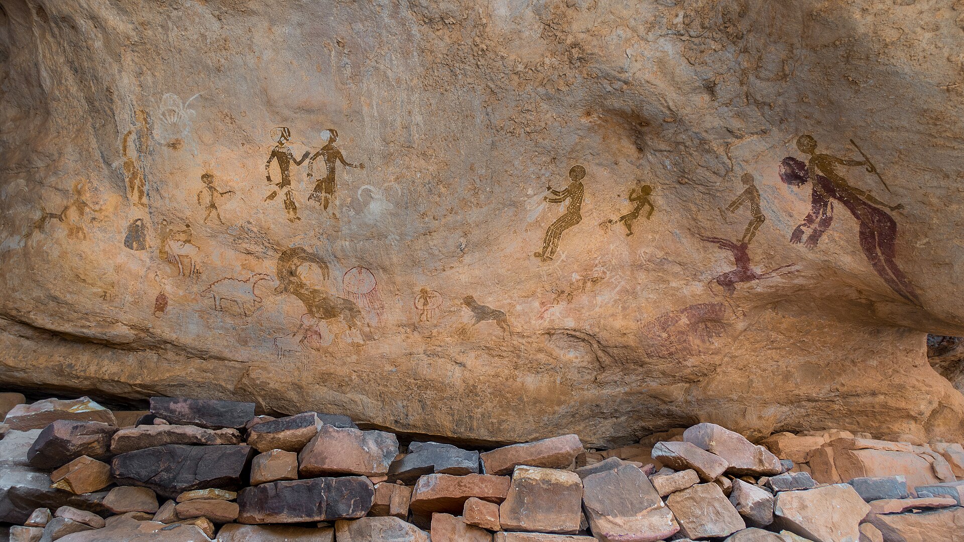
Northeast of Tassili, Chad's sandstone Ennedi Massif — inscribed as a World Heritage site in 2016 — was sculpted by water and wind into canyons and valleys, and its caves hold one of the largest ensembles of rock art in the Sahara. 4 In Niger, the Aïr and Ténéré Natural Reserves — 7,736,000 hectares, on the Danger List since 1992 — are one of Africa's largest protected areas and the last bastion of Saharo-Sahelian wildlife in the country. 5 The German explorer Heinrich Barth, crossing by caravan from Tripoli to Timbuktu in the mid-1800s, became the first European to discover the prehistoric Saharan rock paintings and engravings. 6 With hundreds of thousands of engravings and paintings — pastoral scenes with elephants, giraffe, hippos, aurochs and antelope — the Sahara is very likely the world's largest art museum. 6
Peoples of the Sahara
Habitation is sparse: about 2.5 million people, excluding the Nile valley, in a territory as large as the United States — less than 1 person per square mile (0.4 per square kilometre) (as of 2026). 1 Settlements hold on only where sparse vegetation feeds livestock or dependable water occurs, in a fragile balance with one of Earth's harshest environments. 1 Major pastoral groups include the Regeibat of the northwestern Sahara and the Chaamba of the northern Algerian Sahara. 1 The Teda of the Tibesti are chiefly camel herders, renowned for independence and endurance. 1 The cattle-herding groups of Niger's Ténéré region are believed to have been ancestral Berbers or ancestral Zaghawa. 1
The Tuareg — who call themselves Kel Tamasheq — are Berber-speaking pastoralists ranging from Touat and Ghadames to northern Nigeria and from Fezzan to Timbuktu, their confederations crossing national boundaries. 11 In the 2010s they were estimated at more than two million. 11 Islamic yet matriarchal, they were long renowned for warlike qualities and fierce independence, and Tuareg women have an unusual degree of freedom. 1 Adult males traditionally wore the blue veil, a practice urbanization weakened, and the tifinagh script, related to that of the ancient Libyans, has been preserved. 11 Droughts across southern Mauritania, Senegal, Niger, Burkina Faso and Chad in the 1970s and '80s reduced southern Tuareg numbers and eroded their pastoral way of life. 11
Oasis life depends on gueltas (permanent pools), foggaras — inclined tunnels tapping groundwater under wadi beds — springs (ʿayn) and wells (biʾr). 1 Date palms, barley, millet and henna are staple plantings, and shadoof and noria devices have in places been replaced by motor pumps. 1 Water strictly limits oasis expansion; some oases have seen serious falls in water level, with salinization by evaporation and burial by drifting sand as further dangers. 1 Agriculture appears about 6,000 years ago, with barley and emmer wheat cultivated in Egypt, apparently introduced from Asia. 1 Domesticated livestock had arrived almost 7,000 years ago, turning some groups from hunting and fishing to nomadic pastoralism. 1
Caravans, trade, and exploration
The shift from cattle and horses to camels documents the desert's growing aridity. 1 Camels were used in Egypt by the 6th century BCE, but their prominence in the Sahara dates from only the 3rd century CE; their mobility facilitated nomad involvement in the trans-Saharan trade. 1 They are the primary caravan animal, carrying around 350 pounds (160 kg) and going without water for days. 12
Copper from Mauritania reached the Bronze Age Mediterranean by the 2nd millennium BCE, and trade intensified with the Iron Age civilizations of the Sahara during the 1st century BCE, including Nubia's. 1 Egypt controlled only its neighbouring oases, while Carthage apparently continued Bronze Age commercial ties with the interior. 1 Oasis dwellers were increasingly attacked by the Sanhaja, a Berber clan, and other camel-mounted nomads — many refugees from the anarchy of the late Roman period — and the Haratin were among those subjugated. 1
The largest recorded caravans included the salt caravans from Taoudenni to Timbuktu or Bilma or Aïr; even in its decline in 1908 this caravan numbered 20,000 camels. 12 The southern Tuareg breed zebu cattle and camels. 11 Raiding caravans mattered in pre-European times, as did caravan trading, which declined with motor vehicles. 11
Herodotus described a Berber desert crossing in the 5th century BCE, and Roman expeditions are documented between 19 BCE and 86 CE. 1 Arab geographers wrote of the desert, and the Catalan Atlas of 1375 records it. 1 Laing crossed the Sahara and reached Timbuktu in 1826, dying there before he could return; Caillié, disguised as an Arab, crossed from south to north in 1828. 1
Dust: the Sahara's global reach
The dust travels as the Saharan Air Layer — very dry, dusty air that forms over the Sahara in late spring through early fall and sweeps the tropical North Atlantic every three to five days. 13 It is 2–2.5 miles thick, and its air holds about 50% less moisture than the typical tropical atmosphere — dry enough to weaken a tropical cyclone by promoting downdrafts around it. 13 Its 25–55 mph (10–25 m/s) 'mid-level jet', typically at 6,500–14,500 feet (2,000–4,500 m), substantially increases vertical wind shear and can disrupt a storm's internal heat engine. 13
| Stage | Location | Dust mass |
|---|---|---|
| Departure from the Sahara | 15°W | 182 million tons a year 14 |
| Mid-Atlantic | 35°W | 132 million tons remain in the air 14 |
| Amazon basin | — | 27.7 million tons deposited a year 14 |
| Caribbean | 75°W | 43 million tons settle a year 14 |
This dust carries an estimated 22,000 tons of phosphorus to Amazon soils a year, about as much as the basin loses to rain and flooding. 14 Dust transport correlated with one climate factor: the previous year's Sahel rainfall — more rain meant less dust the following year. 14 At the source, mountains northeast of the Bodélé Depression form a natural wind tunnel over fast-moving diatomite dunes; by one estimate the depression generates about half the mineral dust leaving the Sahara. 8
Water and mineral wealth
The Nubian Sandstone Aquifer System — one of the world's oldest and largest — lies beneath parts of Libya, Egypt, Chad and Sudan. 15 Its reserves equal about 500 years of Nile River discharge, 20 times the North American Great Lakes; the fossil water is not part of the hydrological cycle and can be used only once, much like oil. 15 A 2006 IAEA/UNDP/GEF project produced a computer groundwater model simulating how the water moves through the aquifer and how levels may change over time. 15
After oil was found near I-n-Salah, Algeria, following World War II, major reserves were discovered in Egypt's Western Desert and northeastern Libya and Algeria. 1 Algeria has major iron-ore deposits, Mauritania's Mount Ijill reserves are substantial, and uranium is widely distributed, notably in Niger. 1 Libya built the 'Great Man-Made River Project' for Tripoli's water supply, while Egypt sought new desert cities away from the Nile. 15
Desertification and the future
Desertification is usually defined as a process affecting land that is already arid or semiarid — not simply drought — whose crucial factor is a decline in biological productivity: the vegetation that grows and the animal life it supports. 16 It is complex, involves multiple causes, and proceeds at varying rates in different climates. 17 The Sahelian drought that began in 1968 killed between 100,000 and 250,000 people, disrupted millions of lives and collapsed the agricultural bases of five countries. 17 Paleodeserts — large sand seas stabilized by vegetation — extend well beyond the present margins of core deserts such as the Sahara. 17
The Great Green Wall Initiative, a flagship African Union programme launched in 2007, tackles desertification and land degradation in the Sahel and Sahara. 18 Initially a belt of trees to halt the desert's spread, it has become a continent-wide movement for land restoration and climate-resilient development. 18 The FAO's restoration flagship within it supports integrated ecosystem management, from sustainable dryland management to natural regeneration and water conservation. 19 Its target landscape, between Burkina Faso and Niger, is both a degradation hotspot and a conflict zone, where degradation and acute food insecurity are closely linked. 19 Disturbance can start small: on the Nouakchott–Rosso highway, travel, building and settlement stripped vegetation, sand began to drift, and desertification was under way. 16
Timeline
The African Humid Period begins
During the early and mid-Holocene the Sahara and Sahel entered a humid phase — the African Humid Period — and over the following millennia the desert turned green.
The Green Sahara at its peak
Paleoclimate and archaeological evidence tells us that, 11,000-5,000 years ago, the Earth's slow orbital 'wobble' transformed today's Sahara desert to a land covered with vegetation and lakes, with megalakes as large as the Caspian Sea.
A decadal drought disrupts the Green Sahara
The African Humid Period was punctuated by droughts of decadal-scale duration at about 9.3 kyr bp and 8.2 kyr bp; the 8.2 kyr bp event, recorded in the varved sediments of Lake Yoa in Chad, was likely a rapid response to a weakening of the Atlantic Meridional Overturning Circulation.
Domesticated livestock spread through the Sahara
Among some groups, hunting and fishing were subordinated to nomadic pastoralism after domesticated livestock appeared in the Sahara almost 7,000 years ago; cattle-herding groups of the Ténéré region are believed to have been ancestral Berbers or ancestral Zaghawa.
Rock art begins to record life on the edge of the Sahara
Tassili n'Ajjer's rock art records the climatic changes, the animal migrations and the evolution of human life on the edge of the Sahara from 6000 BC to the first centuries of the present era.
Desiccation empties the Sahara — and Egypt rises on the Nile
Towards the end of the African Humid Period, between 7,000 and 5,000 years ago, progressive desiccation led to widespread depopulation and abandonment of North African sites; the exodus was coincident with the rise of sedentary life and pharaonic culture along the Nile.
Herodotus records a Berber crossing of the Sahara
Herodotus described a desert crossing by an expedition of Berbers during the 5th century bce; Roman interest in the Sahara is documented in a series of expeditions between 19 bce and 86 ce.
Camels become the engine of trans-Saharan travel
Although camels were used in Egypt by the 6th century bce, their prominence in the Sahara dates from only the 3rd century ce, and the greater mobility of nomads facilitated their involvement in the trans-Saharan trade.
Islam spreads across the Sahara along the trade routes
The expansion of Islam into North Africa between the 7th and 11th centuries moved Berber and Arab groups into the Sahara, and Islam eventually expanded through the trade routes, becoming the dominant social force in the desert.
The salt caravans at their twilight
The trans-Saharan salt caravans from Taoudenni to Timbuktu or Bilma or Aïr were among the largest recorded caravans; even in its decline in 1908 this latter caravan numbered 20,000 camels.
The rock art of Tassili n'Ajjer is discovered
It is the rock art (engravings and paintings) that have made Tassili world famous as from 1933, the date of its discovery; 15,000 engravings have been identified to date.
The Great Green Wall is launched
The Great Green Wall Initiative (GGWI) is a flagship programme of the African Union, launched in 2007, to tackle desertification and land degradation in the Sahel and Sahara regions.
The twentieth-century expansion of the Sahara is quantified
A study in the Journal of Climate reports that the Sahara Desert expanded significantly over the twentieth century — by 11%–18% depending on the season, and by 10% when defined using annual rainfall.
Decadal droughts that punctuated the Green Sahara revealed
A Nature study using the annually layered sediments of Lake Yoa in Chad shows that the African Humid Period was punctuated by two droughts of decadal-scale duration, at about 9.3 kyr bp and 8.2 kyr bp.
Frequently asked questions
Where does the name 'Sahara' come from?
The name comes from the Arabic ṣaḥrāʾ, meaning 'desert', and Arabic also calls it Al-Ṣaḥrāʾ al-Kubrā, 'the Great Desert'. 1 It is the largest hot desert in the world. 1
How big is the Sahara?
It depends on the definition. Britannica gives a total of some 3,320,000 square miles (8,600,000 square km), noting the actual area varies as the desert expands and contracts (as of 2026). 1 Under the 100 mm annual rainfall definition the climatological desert covers 7,426,000 square km (as of 2018). 2 Recent reviews cite about 9.2 million square km (as of 2024). 3
Was the Sahara always a desert?
No: 11,000–5,000 years ago the Earth's slow orbital 'wobble' turned it into a land covered with vegetation and lakes. 6 This African Humid Period ran from roughly 14.8 to 5.5 thousand years before present and is known informally as the 'Green Sahara'. 7 Between 7,000 and 5,000 years ago, progressive desiccation led to widespread depopulation of North African sites. 6
How many people live in the Sahara?
Britannica estimates about 2.5 million people, excluding the Nile valley — less than 1 person per square mile (0.4 per square kilometre), as of 2026. 1 In the 2010s more than two million Tuareg were estimated to live across the desert's range. 11
Where are the highest and lowest points in the Sahara?
The highest point is Mount Koussi in the Tibesti Mountains of Chad, at 11,204 feet (3,415 metres). 1 The lowest is Egypt's Qattara Depression, 436 feet (133 metres) below sea level. 1
How much dust does the Sahara send across the Atlantic?
On average 182 million tons of dust a year are carried past the western edge of the Sahara at longitude 15°W, as averaged by satellite observations (as of 2015). 14 Near South America, 132 million tons remain in the air; 27.7 million tons fall over the Amazon basin, and about 43 million tons settle over the Caribbean. 14
Is there water under the Sahara?
Yes: the Nubian Sandstone Aquifer System, one of the oldest and largest aquifers in the world, lies beneath parts of Libya, Egypt, Chad and Sudan. 15 Its reserves are equivalent to about 500 years of Nile River discharge and 20 times the North American Great Lakes, but the fossil water cannot be replenished and can only be used once. 15
What is the Great Green Wall?
The Great Green Wall Initiative is a flagship programme of the African Union, launched in 2007 to tackle desertification and land degradation in the Sahel and Sahara regions. 18 Initially envisioned as a belt of trees to halt the spread of the desert, it has grown into a continent-wide movement for land restoration and climate-resilient development. 18
Knowledge graph
Sources & citations
Every factual claim in this article is drawn from the sources below. Bracketed numbers in the text link to the corresponding source.
- 1
- 2
- 3
- 4
- 5
- 6
- 7
- 8
- 9
- 10
- 11
- 12
- 13
- 14
- 15
- 16
- 17
- 18
- 19