Antarctica
The southernmost continent: a frozen desert of ice, science, and international cooperation.
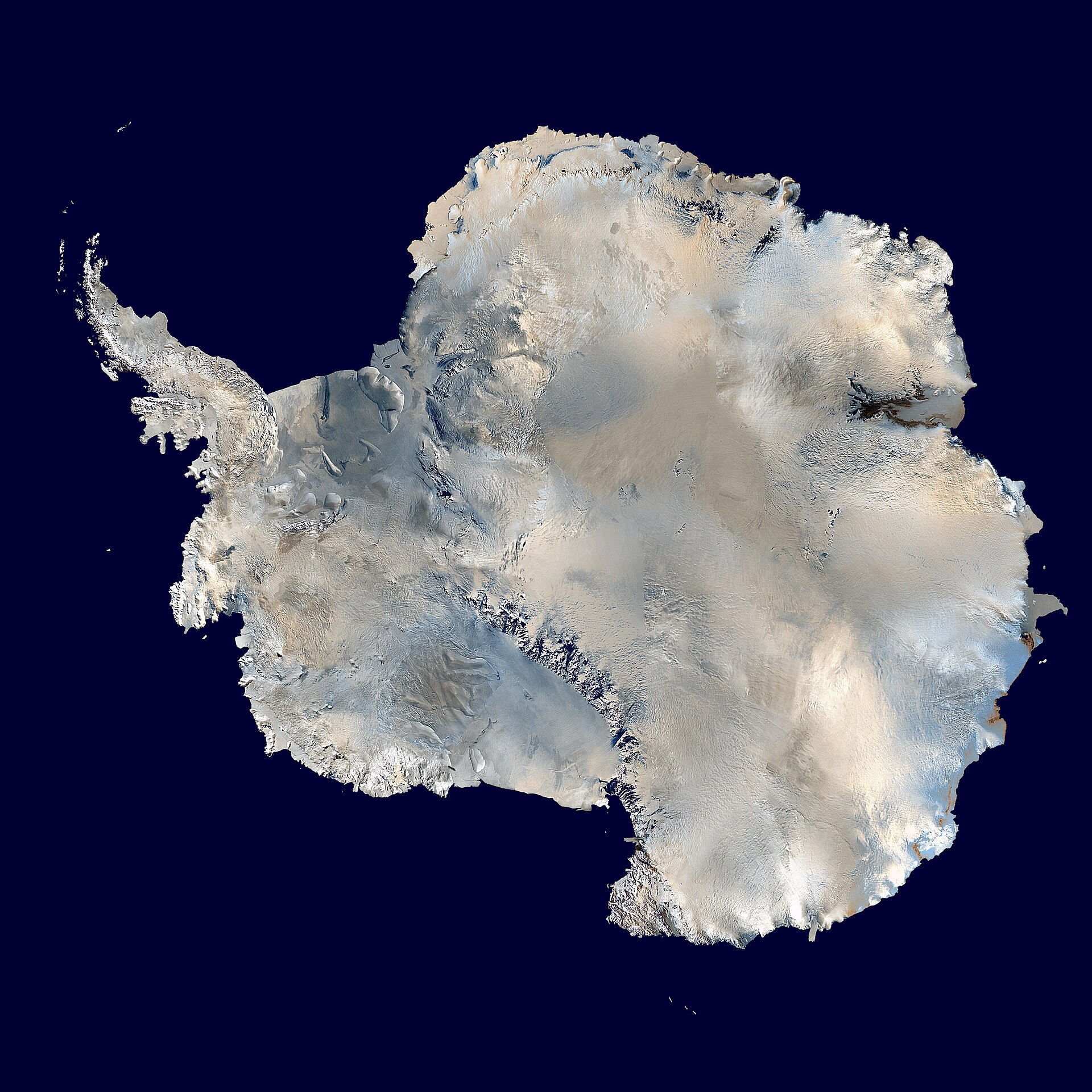

Antarctica is the southernmost and fifth-largest continent — the highest, driest, windiest, and coldest place on Earth. Almost entirely buried under an ice sheet that holds about 90 percent of the world's ice, it has no native population, only a few thousand seasonal researchers and staff. Governed since 1961 by the Antarctic Treaty and preserved for peace and science, the continent drives global climate, ocean currents, and sea level, while its surrounding sea ice grows and melts with the seasons.
Overview
Antarctica is the world's southernmost continent, lying almost concentrically around the South Pole.1 Its name means “opposite to the Arctic.”1 It is about 5.5 million square miles (14.2 million square kilometers) in size, making it the fifth-largest continent.1 Thick ice covers about 98 percent of the land.1
Antarctica is the driest, windiest, coldest, and iciest continent on Earth.1 It is also the world's highest continent, with an average elevation of about 7,200 feet (2,200 meters) above sea level.1 The continental ice sheet contains about 29 million cubic kilometers of ice — about 90 percent of the world's ice and 80 percent of its fresh water.1 Its average thickness is about 1,800 meters.1
Antarctica is one of the rare places on Earth that does not have an Indigenous population.2 Even during the summer period, there are only a few thousand people living in Antarctica.2 Antarctica is not owned by any one nation; it is governed internationally through the Antarctic Treaty system.3 Under Article I of the Antarctic Treaty, Antarctica shall be used for peaceful purposes only.4 Since the Treaty's conclusion, scientific research has been the main activity on the Antarctic continent.5
Geography: a continent of extremes
East and West Antarctica are separated by the approximately 3,400-kilometer-long Transantarctic Mountains.1 The continent spans about 14.2 million square kilometers.1 Ice shelves — including the Ross Ice Shelf, Antarctica's largest, and the Filchner-Ronne Ice Shelf — fringe about 45 percent of Antarctica.61
Antarctica is surrounded by the Southern Ocean, the cold oceanic water mass below 60° S where the southernmost parts of the Atlantic, Pacific, and Indian oceans meet.1 The Southern Ocean connects the Atlantic, Indian and Pacific Oceans.7 The Antarctic Circumpolar Current circles from west to east around Antarctica, and it is the largest current in the world.7 For legal purposes of the Antarctic Treaty, the boundary of latitude 60° S is used; south of it lies the Antarctic Treaty Area.1
Sea ice and land ice: two kinds of ice
In late winter, Antarctic sea ice covers on average about 18.5 million square kilometers (7 million square miles), but only about 2.5 million square kilometers (1 million square miles) remain at summer's end, over the 1981–2010 reference period.11 Almost all Southern Ocean sea ice is seasonal ice that melts away and reforms annually.11 Antarctic sea ice is typically 1 to 2 meters (3 to 6 feet) thick, thinner than Arctic sea ice.11 Sea ice reflects 50 to 70 percent of incoming solar energy, while the darker ocean reflects only 6 percent and absorbs the rest.9 Because Antarctica is a continent surrounded by vast oceans, its sea ice spreads out more freely and tends to nearly completely melt out during the Southern Hemisphere summer.9
Land ice, by contrast, is built from snow that fell on land; an ice sheet is a mass of glacial land ice extending more than 50,000 square kilometers (20,000 square miles).10 The Antarctic Ice Sheet extends almost 14 million square kilometers (5.4 million square miles), roughly the area of the contiguous United States and Mexico combined.10 It contains about 30 million cubic kilometers (7.2 million cubic miles) of ice and measures nearly 4.9 kilometers (3 miles) at its thickest point.10 The East and West Antarctic ice sheets together are the largest single mass of ice on Earth.8
The ice sheet and sea level
Together, the Antarctic and Greenland Ice Sheets contain more than 99 percent of the fresh water ice on Earth.10 The amount of fresh water stored in both ice sheets totals over 68 percent of the fresh water on Earth.10 The continental ice sheet has an average thickness of about 1,800 meters.1 Large high-altitude plateaus on the ice sheets alter storm tracks.10 They also create cold downslope winds called katabatic winds.10
Ice shelves are floating tongues of ice that extend from glaciers grounded on land.6 The Ross Ice Shelf is Antarctica's largest ice shelf.6 After the 2002 Larsen B Ice Shelf disintegration, nearby glaciers in the Antarctic Peninsula accelerated up to eight times their original speed over the next 18 months.6 These shelves, together with others around the continental margins, fringe about 45 percent of Antarctica.1
As measured by the GRACE/GRACE-FO satellites, Antarctica shed approximately 135 gigatons of ice per year between 2002 and 2025, causing global sea level to rise by 0.4 millimeters per year.12 Antarctica alone has the potential to contribute more than a meter (3.3 feet) of sea level rise by 2100.6 By 2500, that potential contribution grows to more than 15 meters (49 feet).6
Climate records and the ozone hole
The ozone hole is not a literal hole.15 It is a region of exceptionally depleted ozone in the stratosphere over the Antarctic that appears at the beginning of Southern Hemisphere spring (August–October).15 Total column ozone values of less than 220 Dobson Units were not observed prior to 1979, so 220 Dobson Units is used as the boundary of the ozone hole region.15 Antarctic science has led to such breakthroughs as the discovery of the ozone hole in 1985.5
Life on and around the ice
There are about 800 species of plant and plantlike organisms in Antarctica, of which 350 are lichens.1 Antarctica is one of the rare places on Earth that does not have an Indigenous population; even during the summer period, only a few thousand people live there.2 The Southern Ocean, by contrast, is home to one of the most abundant animal species on the planet, the Antarctic krill.16
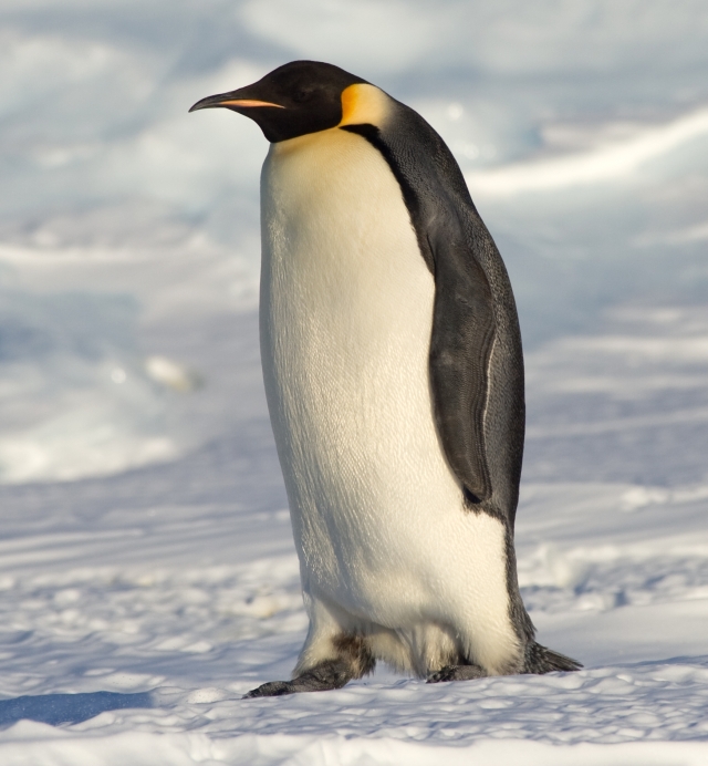
There are 18 species of penguins, 5 of which live in Antarctica, and another 4 on sub-Antarctic islands.17 The emperor is the largest of the 18 penguin species; adults can weigh up to 40 kg at the start of the breeding season.18 Emperor penguins are the only animals that breed during the Antarctic winter, and their colonies range in size from a few hundred to over 20,000 pairs.18 They can dive to over 500 meters; the deepest dive recorded was to 565 meters, and the longest dive on record was 22 minutes.1718 The emperor penguin's conservation status is endangered, with populations projected to decline over the next three generations due to projected climate change.18
Antarctic krill (Euphausia superba) is one of the most abundant and successful animal species on the planet.16 There is an estimated 400 million tonnes of Antarctic krill in the Southern Ocean.16 Antarctic krill aggregate in schools or swarms, where the density of the animal can be as high as 30,000 individuals per cubic meter.16
People and research stations
| Station | Operator | Note |
|---|---|---|
| McMurdo Station | United States | The most populous Antarctic centre and the largest station on the continent; it can accommodate over 1,000 people.219 |
| Amundsen–Scott South Pole Station | United States | The southernmost year-round research station in the world; maximum capacity of 150 personnel in summer, winter population 45.198 |
| Palmer Station | United States | The northernmost U.S. year-round research station in Antarctica.19 |
| Vostok Station | Russia | Site of the lowest air temperature ever measured by a weather station, −89.2 °C, on 21 July 1983.13 |
Approximately 3,500 Americans participate annually in the U.S. Antarctic Program's research and support activities.19 Around 500 people travel south in summer as part of the Australian Antarctic Program; during winter the population across its four stations drops to around 80.2 Tourism in Antarctica has grown from a few hundred tourists each austral summer in the early 1990s to over 100,000 passengers annually.20 Approximately 98 percent of all tourism voyages occur in the Antarctic Peninsula during the seven-month austral summer (October to April).20 Organized commercial tourism to Antarctica started in the mid-1960s, and the self-regulating industry body IAATO was founded in 1991.1
The Antarctic Treaty System
The Antarctic Treaty was signed in Washington on 1 December 1959 by the twelve countries whose scientists had been active in and around Antarctica during the International Geophysical Year (IGY) of 1957-58.4 The 12 original signatory nations were Argentina, Australia, Belgium, Chile, France, Japan, New Zealand, Norway, South Africa, the United Kingdom, the United States of America, and the Soviet Union.21 The Treaty entered into force on 23 June 1961, and the total number of Parties is now 58.4 Since 1959, 46 other countries have acceded to the Treaty; there are now 29 Consultative Parties and 29 Non-Consultative Parties.22 Australia hosted the first meeting of Antarctic Treaty member nations in Canberra in 1961.21
The Protocol on Environmental Protection to the Antarctic Treaty — the Madrid Protocol — was signed in Madrid in 1991 and entered into force in early 1998.21 It prohibited Antarctic mineral resource activities and required environmental impact assessments.2321 Article 2 of the Protocol designates Antarctica as “a natural reserve, devoted to peace and science.”5 The prohibition on Antarctic mineral resource activities in Article 7 cannot be removed or amended unless a binding legal regime on Antarctic mineral resource activities is in force.23
Exploration history
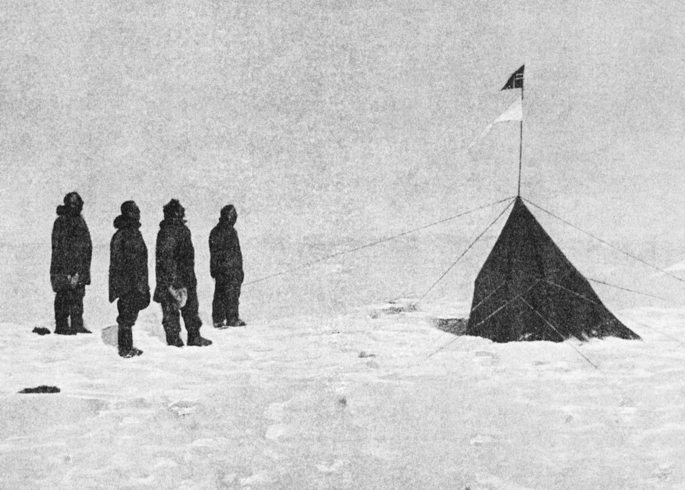
Early penetration of the Southern Ocean in the search for fur seals led in 1820 to the discovery of the continent.1 Roald Amundsen reached the South Pole on 14 December 1911; Captain Scott and his party arrived on 17 January 1912.24 Roald Engelbregt Gravning Amundsen (1872–1928) was born into a Norwegian shipping family and chose polar exploration over the medical career his mother wanted for him.24 No human visited the South Pole again until November 1956, when construction began on the original Amundsen-Scott South Pole Station.8
The International Geophysical Year (IGY) actually lasted 18 months, from July 1957 to December 1958, and during it 12 nations established 50 Antarctic research stations.2119 In 1958, the Special Committee on Antarctic Research (SCAR) was established to provide an international coordinating body for Antarctic science.21 That cooperation set the stage for the Antarctic Treaty, and the U.S. Antarctic Program was founded in 1959 following the IGY.2119 In February 2012, Russian scientists finished penetrating more than two miles through the Antarctic ice sheet to Lake Vostok, a huge freshwater lake buried under the ice for millions of years.25 The drilling reached the lake 3,769 meters (12,366 feet) down — the first sampling of the biggest subglacial lake.25

Antarctica in a warming world
On September 17, 2025, Antarctic sea ice likely peaked with a maximum extent of 17.81 million square kilometers (6.88 million square miles) — the third lowest maximum in the satellite record that began in 1979.26 The 2023 Antarctic sea ice maximum of 17.07 million square kilometers on September 9 was the record low maximum.26 The 2025 maximum extent was 900,000 square kilometers (348,000 square miles) below the 1981 to 2010 average maximum extent.26 Almost all Southern Ocean sea ice is seasonal ice that melts away and reforms annually.11
Worldwide, more than 100 million people currently live within 1 meter (3.3 feet) of average sea level.6 The Antarctic Peninsula is among the fastest warming regions of the planet, having warmed almost 3 °C over the last 50 years.14 If the entire Antarctic Ice Sheet melted, sea level would rise about 58 meters (190 feet).10
The ice sheet by the numbers
Antarctica's ice is measured in units that resist everyday intuition. The continental ice sheet contains about 29 million cubic km of ice — about 90 percent of the world's ice and 80 percent of its fresh water — with an average thickness of about 1,800 meters1. The Antarctic Ice Sheet measures nearly 4.9 kilometers (3 miles) at its thickest point10. For comparison, an ice sheet is defined as a mass of glacial land ice extending more than 50,000 square kilometers (20,000 square miles)10, a threshold Antarctica exceeds many times over. The East and West Antarctic ice sheets cover about 98 percent of the continent and are the largest single mass of ice on Earth, covering almost 5.4 million square miles and containing 6.4 million cubic miles of ice8. Together they hold approximately 61 percent of all fresh water on Earth, an amount equivalent to about 190 feet of sea-level rise8.
The continent itself is about 5.5 million square miles (14.2 million square km) in size and is the fifth-largest continent1. It is the world's highest continent, with an average elevation of about 7,200 feet (2,200 meters) above sea level1. Antarctica is the world's southernmost continent and also the driest, windiest, coldest, and iciest continent1. Its name means "opposite to the Arctic"1. Ice shelves — including the Ross Ice Shelf and the Filchner-Ronne Ice Shelf — fringe about 45 percent of Antarctica1.
Sea ice, seasonal ice and the Southern Ocean
Because Antarctica is a continent surrounded by vast oceans, its sea ice spreads out more freely, is often much thinner than Arctic sea ice, and tends to nearly completely melt out during the Southern Hemisphere summer9. Almost all Southern Ocean or Antarctic sea ice is seasonal ice that melts away and reforms annually11. In late winter, Antarctic sea ice covers on average about 18.5 million square kilometers (7 million square miles), but only about 2.5 million square kilometers (1 million square miles) remain at summer's end (1981–2010 reference period)11. Recent seasons have run below that baseline: the 2025 Antarctic maximum extent was 900,000 square kilometers (348,000 square miles) below the 1981 to 2010 average maximum extent26.
The ocean around the continent is itself a distinct system. Antarctica is surrounded by the Southern Ocean, and the Antarctic Circumpolar Current circles from west to east around Antarctica and is the largest current in the world7. The Southern Ocean is the cold oceanic water mass below 60° S, where the southernmost parts of the Atlantic, Pacific, and Indian oceans meet1. Large high-altitude plateaus on the ice sheets alter storm tracks and create cold downslope winds called katabatic winds10.
Cold, life and the human footprint
Antarctica's cold is recorded in extremes. The lowest air temperature ever measured by a weather station, -89 degrees Celsius (-128 degrees Fahrenheit), was recorded at Russia's Vostok Station in July 198313. A 2018 study revised the satellite record: the coldest Antarctic sites actually reach -98 degrees Celsius (-144 degrees Fahrenheit), observed during the southern polar night, mostly in July and August13. The ozone hole is not a literal hole but a region of exceptionally depleted ozone in the stratosphere over the Antarctic that appears at the beginning of Southern Hemisphere spring (August–October)15.
Life on and around the ice includes species with remarkable capabilities. Emperor penguins can dive to over 500 meters17; the deepest emperor penguin dive recorded was to 565 meters, and the longest dive on record was 22 minutes18. Antarctic krill (Euphausia superba) is one of the most abundant animal species on the planet, with an estimated 400 million tonnes in the Southern Ocean16.
Human presence is concentrated in a few centres. McMurdo Station on Ross Island, operated by the United States, is the most populous Antarctic centre and can accommodate over 1,000 people2. USAP operates three year-round research stations and a research vessel: McMurdo Station (the largest station on the continent), Amundsen-Scott South Pole Station (the southernmost year-round research station in the world), and Palmer Station19. Amundsen-Scott South Pole Station has a maximum capacity of 150 personnel in summer, and its winter population is 458. Approximately 3,500 Americans participate annually in USAP's research and support activities19. No human visited the South Pole again until November 1956, when construction began on the original Amundsen-Scott South Pole Station; its 18-man U.S. Navy crew was the first to overwinter at the South Pole8. The Vostok drilling reached the lake 3,769 meters (12,366 feet) down; water under great pressure from the ice above shot up the bore hole and froze25. Robin E. Bell of Lamont-Doherty Earth Observatory described Vostok as the biggest subglacial lake, and the 2012 breakthrough was the first sampling of a subglacial lake25.
Timeline
The continent is first sighted
Early penetration of the Southern Ocean in the search for fur seals led in 1820 to the discovery of the continent.1
Amundsen reaches the South Pole
Roald Amundsen's Norwegian party became the first to reach the South Pole; Captain Scott and his party arrived 34 days later, on 17 January 1912.24
The Antarctic Treaty is signed
Twelve countries signed the Treaty in Washington, D.C., dedicating Antarctica to peaceful purposes and scientific research.4
Coldest temperature ever recorded
The lowest air temperature ever measured by a weather station, −89.2 °C (−128.6 °F), was recorded at Russia's Vostok Station.13
The ozone hole is discovered
Antarctic science produced the discovery of the ozone hole in 1985, one of the breakthroughs cited by the Antarctic Treaty Secretariat.5
The Madrid Protocol is signed
The Protocol on Environmental Protection to the Antarctic Treaty prohibited mining, required environmental impact assessments, and designated Antarctica a natural reserve; it entered into force in early 1998.21
Larsen B Ice Shelf disintegrates
The Larsen B Ice Shelf on the Antarctic Peninsula disintegrated; nearby glaciers accelerated up to eight times their original speed over the next 18 months.6
Lake Vostok is reached
Russian scientists penetrated more than two miles of ice to reach Lake Vostok, the biggest subglacial lake, 3,769 meters below the surface.25
Coldest surface temperatures measured by satellite
A study published in Geophysical Research Letters showed the coldest Antarctic sites reach −98 °C (−144 °F) during the southern polar night.13
WMO verifies the continental heat record
The WMO recognized 18.3 °C at Argentina's Esperanza station as the new record high temperature for the Antarctic continent.14
Frequently asked questions
Who owns Antarctica?
Antarctica is not owned by any one nation; it is governed internationally through the Antarctic Treaty system.3 Seven signatory countries — Argentina, Australia, Chile, France, New Zealand, Norway, and the United Kingdom — hold territorial claims in Antarctica, some of them overlapping.4 Article IV of the Treaty preserves the status quo on those claims while the Treaty is in force.4
Does anyone live in Antarctica permanently?
Antarctica is one of the rare places on Earth that does not have an Indigenous population.2 Even during the summer period, there are only a few thousand people living in Antarctica.2 Scientific research has been the main activity on the Antarctic continent since the Treaty's conclusion.5
What is the difference between sea ice and land ice?
Sea ice is frozen ocean water that forms, grows, and melts entirely in the ocean, while icebergs, glaciers, and ice shelves float in the ocean but originate on land.9 If the entire Antarctic Ice Sheet — land ice — melted, sea level would rise about 58 meters (190 feet).10
How cold does Antarctica get?
The lowest air temperature ever measured by a weather station, −89.2 °C, was recorded at Russia's Vostok Station on 21 July 1983.13 Satellite measurements show that the coldest Antarctic sites actually reach −98 °C during the southern polar night, mostly in July and August.13
What animals live in Antarctica?
There are 18 species of penguins, 5 of which live in Antarctica, and another 4 on sub-Antarctic islands.17 Antarctic krill is one of the most abundant animal species on the planet, with an estimated 400 million tonnes in the Southern Ocean.16 There are about 800 species of plant and plantlike organisms in Antarctica, of which 350 are lichens.1
What does the Antarctic Treaty say?
Under Article I of the Treaty, Antarctica shall be used for peaceful purposes only.4 Articles II and III guarantee freedom of scientific investigation in Antarctica and the free exchange of scientific observations and results.4 The Treaty was signed in Washington on 1 December 1959 by twelve countries, and the total number of Parties is now 58.4
Can tourists visit Antarctica?
Tourism in Antarctica has grown from a few hundred tourists each austral summer in the early 1990s to over 100,000 passengers annually.20 Approximately 98 percent of all tourism voyages occur in the Antarctic Peninsula during the seven-month austral summer (October to April).20
Knowledge graph
Sources & citations
Every factual claim in this article is drawn from the sources below. Bracketed numbers in the text link to the corresponding source.
- 1
- 2
- 3
- 4
- 5
- 6
- 7
- 8
- 9
- 10
- 11
- 12
- 13
- 14
- 15
- 16
- 17
- 18
- 19
- 20
- 21
- 22
- 23
- 24
- 25
- 26