Venice
How 118 islands became the Most Serene Republic, why the floods of 1966 and 2019 broke records, and how the MOSE barriers now stand between Venice and the Adriatic.
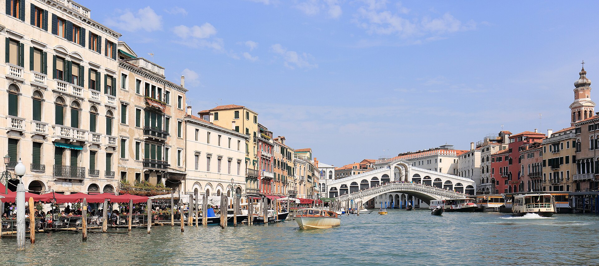
Venice is the lagoon city of the northern Adriatic: 118 islands joined by canals and bridges inside a crescent-shaped lagoon, once the capital of a maritime republic that dominated the eastern Mediterranean, and today a World Heritage site fighting to stay habitable. This fact file gathers the evidence behind the story: UNESCO’s 1987 inscription and the advisory missions that twice recommended placing the site on the Danger List; the tide records — 194 cm on 4 November 1966 and 187 cm on 12 November 2019; the MOSE system of 78 mobile gates, operational since October 2020 and now raised about 20 times a year; the shifting statistics of residents, visitors and cruise ships; and the scientific record of a lagoon whose salt marshes have shrunk by half since 1927.
A city built on water
Venice took shape in the 5th century, spread across 118 small islands, and had become a major maritime power by the 10th century.1 UNESCO calls the whole city an extraordinary architectural masterpiece, one in which even the smallest building holds works by some of the world's greatest artists, from Giorgione and Titian to Tintoretto and Veronese.1 The geography is precise: Venice sits at the north-western end of the Adriatic Sea, on an archipelago in the crescent-shaped Laguna Veneta, which stretches some 51 km from the marshes of Jesolo to the drained lands beyond Chioggia.2 The heritage frame is just as exact: the World Heritage property that encloses the city and its lagoon covers 70,176.4 hectares in the Veneto region of north-eastern Italy.1 Britannica situates the same city in history: a maritime republic's island capital, late medieval Europe's greatest seaport and the continent's commercial and cultural link to Asia.2
The city's physical logic begins with water, because when the tiny islands were consolidated into a single urban system the only traces left of the primitive topography were canals, from the Giudecca Canal and St Mark's Canal to the Grand Canal and the network of small rii that serves as the veritable arteries of a city on water.1 Outside the islands, the shallow lagoon is protected by a line of sandbanks, the lidi, whose three gaps, the porti, carry the roughly one-metre tides and the city's maritime traffic.2 The administrative comune embraces the 145-km perimeter of the lagoon, taking in the urban and industrial areas of Mestre and Marghera and the Marco Polo International Airport at Tessera.2 Inside that frame the historic centre has been losing its people for a century: three-fourths of the comune's population at the start of the 20th century, more than half at mid-century, less than one-fourth by the start of the 21st.2
The lagoon: a living, fragile machine
For UNESCO the lagoon is a semi-lacustral habitat that has become vulnerable as a result of irreversible natural and climate changes.1 In this coherent ecosystem the muddy shelves count as much as the islands, and the pile-dwellings, fishing villages and rice-fields need protection no less than the palazzi and churches.1 In this lagoon, covering 70,176.4 ha, nature and history have been closely linked since the 5th century, when Venetian populations fleeing barbarian raids found refuge on the sandy islands of Torcello, Jesolo and Malamocco.1 What began as a temporary refuge for land-dwelling peasants and fishermen gradually became permanent, and eventually a maritime power.1 The city's own management plan supplies the long view: a millennia-old story of resilience and resistance to the hazards that have threatened the city for more than 1,600 years.3
The bathymetric record shows what change looks like in numbers: comparing surveys of 1927, 1970 and 2002, researchers found that the lagoon's salt marshes shrank by more than 50%, from 68 km² to 32 km².4 Over the same period the subtidal flats between -0.75 and -2.00 m grew from 88 km² to 206 km², a mark of a lagoon that has deepened markedly.4 Why that matters for defence is understood: shallower, marsh-lined margins absorb wave energy, which is why the defence system now includes the reconstruction of salt marshes alongside its engineering.3 This is the machine the city must keep alive, a lagoon whose marshes have shrunk by more than half since 1927 and whose defences now run from the seabed gates to the reconstruction of its own margins.3
From refuge to the Most Serene Republic
The origin story the sources support begins with flight: during Attila's invasion in 452, the islets of Torcello gave asylum to the inhabitants of Altino.5 By 697 the lagoon communities had elected their first leader: Paoluccio Anafesto became the first Doge at Heraclea, in a general assembly of all the Venetian nobility, people and clergy.5 The city's religious centre took shape over the following centuries: in 829 the body of Saint Mark was transported from Alexandria in Egypt to Venice.6 The first church of San Marco was consecrated in 832, the present basilica was begun in 1063 under Doge Domenico Contarini, and it was consecrated in 1094.6
After the Fourth Crusade and the conquest of Constantinople in 1204, marbles and works of art were brought to the basilica — the four horses, the icon of the Madonna Nicopeia and enamels from the Pala d'Oro among them — and they remain part of its treasury.6 From the early 15th century Venice amassed the land empire known as the terraferma, stretching from the Istrian Peninsula to the borders of Milan and from the Po River to the Alps.2 At Lepanto in 1571 the news of the Turkish defeat broke out in music and dancing and rejoicings of all sorts in Venice, while the government offered thanksgiving in the church of Saint Mark.7 Through all of it, as UNESCO stresses, Venice never ceased consolidating its position in the lagoon while defending its trading markets against the Arabs, the Genoese and the Ottoman Turks.1 The Republic fell in 1797, the basilica's chronology marking the year in a single entry.6 Since then the city has held an unrivaled place in the Western imagination, endlessly described in prose and verse.2
The traffic of the civilised world centred at Rialto.
Pompeo Molmenti, Venice: Its Individual Growth from the Earliest Beginnings to the Fall of the Republic, Volume 1 (1906)
Lepanto, where many a noble sacrificed his life for his country and his faith, gave a brilliant proof that the Venetian patrician was ready at a moment's notice to abandon the pleasures of the city for the rude experiences of war.
Pompeo Molmenti, Venice: Its Individual Growth from the Earliest Beginnings to the Fall of the Republic, Volume 2 (1906)
Landmarks of Venice
The table below gives each landmark structure, where to find it and what to see there.1 Together they carry the whole story, from the Byzantine treasure of the basilica to the Gothic government of the palace and the waters that made the city work.2
| Structure | Where | What to see | Source key |
|---|---|---|---|
| Rialto Bridge | Narrowest point of the Grand Canal, at the heart of Venice.8 | A stone arch bridge built in the closing years of the 16th century by Antonio da Ponte and his nephew Antonio Contino following a design competition, and the oldest bridge across the canal.8 Its lower chord spans only 25 m and its width is 20 m; 6,000 timber piles were driven under each abutment to carry the arch on the soft alluvial soil.8 The first bridge at the location was the wooden pontoon bridge Ponte della Moneta, designed in 1178 by Nicolò Barattieri.8 | britannica-rialto — Encyclopaedia Britannica, the Rialto Bridge entry.8 |
| St Mark's Basilica | Piazza San Marco.6 | The present basilica was begun in 1063 and consecrated in 1094, replacing the first church consecrated in 832.6 Its treasury holds the marbles and works of art brought from Constantinople after 1204, including the four horses and the icon of the Madonna Nicopeia.6 | basilica-chronology — Procuratoria di San Marco, essential chronology.6 |
| Doge's Palace | Piazzetta San Marco.9 | A masterpiece of Gothic art with Renaissance and Mannerist elements, and the residence of the Doge, the highest and oldest magistrate of the Venetian Republic.9 The wing towards the St Mark's Basin was rebuilt from 1340, the wing towards St Mark's Square took its present form from 1424, and the canal-side wing housing the Doge's apartments was built between 1483 and 1565.9 The Italian State made it a public museum in 1923, and in 1996 the Doge's Palace became part of the Civic Museums of Venice network.9 | palazzo-ducale-history — MUVE, the Doge's Palace building and history.9 |
| Piazza San Marco and the six sestieri | The civic heart of the city and its six historic quarters.1 | An incomparable series of architectural ensembles, from great monuments such as Piazza San Marco and the Piazzetta, with the cathedral, the Palazzo Ducale and the Marciana and Correr museums, to the more modest residences in the calli and campi of the six sestieri.1 | unesco-venice-lagoon — UNESCO World Heritage List, criterion (iv).1 |
| Grand Canal and the Malamocco lock | Through the historic centre to the Malamocco inlet.10 | The city's main waterway, set in the network of canals and rii on which the city is built.1 At Malamocco the navigation lock, about 370 m long and 48 m wide and protected by an outer breakwater, allows ships to keep transiting the inlet even when the MoSE gates are raised.10 | mose-progetto — MOSE Venezia, the system project page.10 |
| Santa Maria della Salute | Standing in the lagoon landscape of the historic centre.1 | The golden-age monument of the Republic in that landscape, part of the unforgettable cityscape whose beauty inspired Canaletto, Guardi and Turner.1 | unesco-venice-lagoon — UNESCO World Heritage List, criterion (i).1 |
Acqua alta: the floods that shaped the city
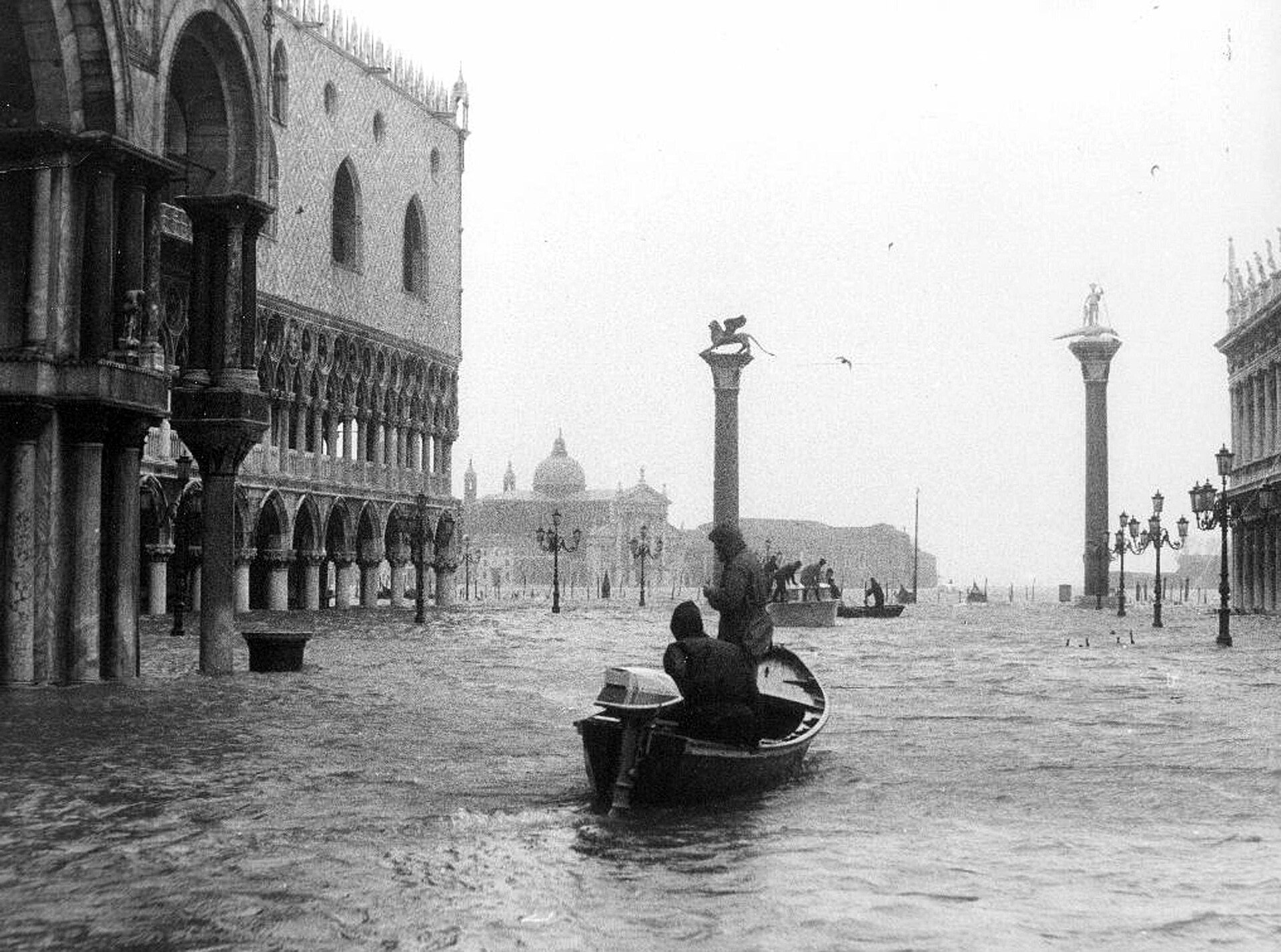
The hazard has a definition at UNESCO: high water is a threat to the integrity of the property's cultural, environmental and landscape values.1 The growth in the frequency and levels of high tides, along with wave motion from motor boats, is a main cause of deterioration and damage to building structures and urban areas.1 Alongside the mobile barriers and tourism pressure, the tides are named among the most pressing management issues for the site.1 The defining catastrophe came on 4 November 1966, when a storm surge of 194 cm at the Punta della Salute gauge left Venice and the other lagoon centres completely submerged under a metre of water.11 The awareness then emerged clearly, the chronology records, that the city's survival would never again be certain unless action was taken to defend it.11
The meteorology behind that record was extreme: the meteorological contribution reached 185 cm while the maximum coincided with an astronomical tide of only 9 cm.12 At the Punta della Salute gauge the reading of 194 cm remains the highest value ever recorded.12 The modern record's three most devastating events are those of 4 November 1966 at 194 cm, 29 October 2018 at 156 cm and 12 November 2019 at 187 cm.12 During the 2019 event UNESCO reported that the city was being hit by the highest tide in more than 50 years.13 Damage estimates for the four most devastating events run from €8,000 million in 1966 and €20 million in 2008 to €47 million in 2018 and €1,000 million in 2019.12 UNESCO reads the site as highly vulnerable to climate change, with heavy rains and floods increasing in frequency and intensity in the Mediterranean.13 The pressures recorded in the same statement combine overtourism, damage caused by a steady stream of cruise ships, and the potential negative effects of new developments.13 In response to 1966, more than thirty international committees were formed under the administrative umbrella of UNESCO to preserve the city's cultural heritage.14
MOSE: the machine that holds back the sea
A city under pressure: tourism, residents and the lagoon
The social crisis has an official shape: exceptionally high tourism pressure has produced a partial functional transformation of Venice and the lagoon's historic centres, with residents' housing replaced by accommodation and activities serving tourism.1 The 2023 World Heritage Committee asked for a sustainable tourism model that reduces the exceptionally high number of visitors, significantly improves residents' quality of life and returns urban areas to residential use.17 The 2024 joint mission found mass tourism, or overtourism, to be one of the most critical challenges for the property, exerting a major negative impact on its Outstanding Universal Value.3 The numbers behind the judgement are municipal: the resident population of the comune stood at 251,294 persons on 31 December 2025, according to the Statistical Office of the Comune di Venezia.18 That official base is national as well as local: ISTAT, the Italian statistics institute, publishes figures drawn from the registry offices of the comuni and the population census.19
The counter-measures are experimental and contested: in 2024 an access fee for day-trippers in the historic centre, Giudecca and San Giorgio ran for 29 days between April and July, requiring booking and a payment of €5 per person.3 It produced nearly 500,000 paid registrations and an income of approximately €2.5 million, yet the number of visitors on days when registration was obligatory did not decrease.3 The Committee welcomed the experimental system for managing tourist flows, based on an entry fee and a compulsory booking method.17 Cruise traffic enters the same ledger: the mission was told of 235,000 passengers arriving by ship each year, a number projected to rise to 376,000, an increase of 60%.3 The city also monitors itself: the Smart Control Room established in 2020 integrates local police, public transport, waste collection, ambulance and boat traffic control with environmental data.3 On shipping the mission recommended caution over extending routes in the lagoon and urged abandoning plans to reopen the Vittorio Emanuele Channel.3
Art and conservation: the Republic’s afterlife
UNESCO's criteria read like a catalogue of influence: Venetian architecture and monumental art spread first through the Serenissima's fondachi, the trading stations along the Dalmatian coast, in Asia Minor, Egypt, the Ionian islands, the Peloponnese, Crete and Cyprus.1 When the power at sea faded, the painters carried the argument: Bellini and Giorgione, then Tiziano, Tintoretto, Veronese and Tiepolo completely changed the perception of space, light and colour, leaving a decisive mark on painting across Europe.1 The city is inscribed as a link between East and West, between Islam and Christianity, living on through thousands of monuments and vestiges of times gone by.1 Criterion (i) is blunt about the beauty: Venice is a unique artistic achievement, a city that seems to float on the waters of the lagoon, an unforgettable landscape that inspired Canaletto, Guardi and Turner.1 The Queen of the Seas extended her horizon well beyond the lagoon: it was from Venice that Marco Polo (1254–1324) set out in search of China, Annam, Tonkin, Sumatra, India and Persia.1
Conservation is the modern institution built on that inheritance: Save Venice was established in response to the serious damage caused by the November 1966 floods, the highest tide of the last century.14 First known as the Venice Committee of the International Fund for Monuments, it became an independent charitable organisation in 1971.14 Since then Save Venice has funded the conservation of more than 2,000 individual artworks, and in 2015 it established the Rosand Library and Study Center in Venice.14 After the fall of the Republic the Doge's Palace itself housed cultural institutions such as the Biblioteca Marciana, from 1811 to 1904.9 The palace became a public museum in 1923, when the Italian State appointed the City Council to manage it, and in 1996 it joined the Civic Museums of Venice network.9
UNESCO World Heritage and the danger debate
Venice and its Lagoon was inscribed on the World Heritage List in 1987 under all six cultural criteria — (i) to (vi).1 UNESCO describes an emblematic site that has faced several threats for years: high tides and wave motion on the foundations of historic buildings, human-induced effects on the lagoon ecosystem, and the exodus of inhabitants.20 In both 2021 and 2023 the World Heritage Centre and the Advisory Bodies considered that the property continued to face ascertained and potential danger, and recommended its inscription on the List of World Heritage in Danger.3 The Committee declined to follow that advice: in Decision 44 COM 7B.50 it decided not to add the property to the danger list, asking Italy instead to propose corrective measures with a timeframe for implementation.3
The 2023 decision's demands were operational: fully complete and operationalise the MoSE system, ensure its long-term management and maintenance, and establish the proposed management authority with urgency.17 It also asked for close joint monitoring of the system's impacts, during construction and operation, and for continued work on measures to mitigate any negative effects on the lagoon ecosystem.17 The decision noted the temporary barriers protecting the Basilica of San Marco from high-water events not managed by the MoSE, and asked for detailed documentation of plans to elevate the entire San Marco insula.17 The Committee welcomed the reconfirmation of the ban on large ships from the San Marco Basin and the Giudecca Canal, along with continuing efforts to find docking options for large ships outside the lagoon.17 UNESCO had welcomed the Italian government's decision to ban large cruise ships from the lagoon in April 2021, which the World Heritage Committee had urged in 2014.20
Governing a lagoon city today
The city now runs on integrated control: the Smart Control Room established in 2020 serves as the management tool for city services — local police, public transport, waste collection, ambulance and boat traffic control — alongside environmental data.3 For the lowest part of Venice, the San Marco area that floods before the MoSE threshold is reached, the defence project involves raising the banks of the waterfront to a height of 1.10 m and constructing a system of valves and pumps.3 The wider defence effort includes reinforcement of 80 km of coastline, local-defence works raising and reinforcing embankments, and the protection and reconstruction of salt marshes.3
Growth pressures are being planned against this background: the capacity of the airport will rise in the medium term to 15 million passengers a year — doubling current capacity — and up to 20 million by 2037.3 Cruise passenger numbers point the same way, from 235,000 a year towards the projected 376,000.3 The Committee's programmes of work keep pushing for tourism management and the requalification of urban areas for residents.17 And the caution over shipping and port projects remains in force, with the lagoon cast as both a protected object and a working piece of infrastructure.3
The future of the lagoon city
The MoSE ledger has two sides: the barriers have already proved themselves against repeats of the most extreme event, the flood of 1966.12 It is raised roughly 20 times a year, much more often than it was originally foreseen, for a few hours at a time.3 The advisory bodies want its effects monitored as well, from the reported loss of marine seagrass to the lagoon's wider ecological balance.3 And the long-term vision remains incomplete on the 2023 decision's own terms: the MoSE system is to be fully completed and operationalised, with its management authority established.17
The underlying threat has not gone away: rising water levels and subsidence of the land on which Venice is built threaten the continued existence of the city in its present form.2 The trend line in the Mediterranean runs towards heavier and more intense rains and floods.13 The mission's finding stands as the critical challenge: mass tourism exerts a major negative impact on the outstanding universal value of the property.3 And the city's own management plan supplies the closing image: a millennia-old story of resilience and tireless resistance to hazards for more than 1,600 years.3
Timeline
Attila’s invasion drives the first refugees to the lagoon islets
During Attila’s invasion in 452, the islets of Torcello gave asylum to the inhabitants of Altino — the founding movement of the lagoon settlements that would become Venice.
Election of the first Doge
The first Doge, Paoluccio Anafesto, was elected in 697 at Heraclea, in a general assembly of all the Venetian nobility, people and clergy.
The relics of Saint Mark reach Venice
The body of Saint Mark was transported from Alexandria in Egypt to Venice in 829, under Doge Giustiniano Partecipazio — the origin of the basilica and of the city’s winged-lion emblem.
Reconstruction of St Mark’s Basilica begins
Under Doge Domenico Contarini the present church of San Marco was begun in 1063; it was consecrated in 1094.
The Fourth Crusade carries Constantinople’s treasures to Venice
After the conquest of Constantinople in 1204, marbles and works of art — including the four horses, the Madonna Nicopeia and enamels from the Pala d’Oro — were brought to the basilica and remain in its treasury.
Venice celebrates the victory of Lepanto
On news of the Turkish defeat at Lepanto, Venice broke out into music, dancing and rejoicings, while the government offered thanksgiving in the church of Saint Mark. Molmenti recalls that many a noble sacrificed his life there for his country and his faith.
Fall of the Republic of Venice
The thousand-year Republic ended in 1797; the Doge’s Palace, its political heart, was later turned over to cultural institutions such as the Biblioteca Marciana (1811–1904).
The great flood: 194 cm at Punta della Salute
A catastrophic storm surge put the Punta della Salute gauge at 194 cm — still the highest tide ever recorded. Venice and the other lagoon centres were submerged under a metre of water, and it became clear that the city’s survival would never again be certain without action to defend it.
The first special law for Venice
Law no. 171 declared the problem of Venice one of “pre-eminent national interest” and affirmed the physical unity and continuity of the lagoon, opening the modern era of safeguarding legislation.
Venice and its Lagoon joins the World Heritage List
The city and its lagoon were inscribed together in 1987 under all six cultural criteria, from the city’s artistic achievement to its role in the discovery of the world through Marco Polo.
The MoSE prototype is lowered into the Treporti channel
The experimental MoSE gate was placed in the water at the Treporti channel in the presence of government ministers — the first full-scale test of the mobile-barrier concept.
Construction of the MoSE system gets the go-ahead
After the CIPE assigned €450 million as first financing in November 2002, the Comitatone unanimously approved the move to executive design and construction; works began with the breakwater outside the Malamocco inlet.
MOSE enters service
Since October 2020 the barriers have been raised whenever the water rises above 130 cm — roughly 20 times a year, much more often than originally foreseen; the MoSE had been set up as the flagship answer to the acqua alta.
Italy bans large cruise ships from the lagoon
UNESCO welcomed the Italian government’s decision to ban large cruise ships from the Venice Lagoon, which the World Heritage Committee had urged since 2014.
Normal operation of MOSE, and the first access-fee season
The Comune di Venezia marks 2024 as the start of normal operation of the MoSE system; the same year, the access-fee trial for day-trippers ran for 29 days (nearly 500,000 paid registrations) and the Committee reviewed the state of conservation again.
Frequently asked questions
Where is Venice and how was it founded?
Venice lies at the north-western end of the Adriatic Sea, on an archipelago in the crescent-shaped Laguna Veneta, which stretches some 51 km from Jesolo to Chioggia.2 It was founded in the 5th century, spread over 118 small islands and had become a major maritime power by the 10th century.1
Why is Venice a UNESCO World Heritage site?
Venice and its Lagoon was inscribed on the World Heritage List in 1987 under all six cultural criteria — (i) to (vi).1 UNESCO describes the whole city as an extraordinary architectural masterpiece in which even the smallest building contains works by some of the world's greatest artists.1
What was the worst flood in Venetian history?
The highest tide ever recorded came on 4 November 1966, when a storm surge put the Punta della Salute gauge at 194 cm and the city was completely submerged under a metre of water.11 The meteorological contribution reached 185 cm while the astronomical tide was only 9 cm.12
How does the MoSE system work?
The system consists of 4 barriers with 78 mobile gates, plus 8 reserve gates, installed at the lagoon's three inlets.10 In normal tides each gate lies full of water on the seabed and rises on two hinges when the water is expelled with compressed air.15
How often are the MoSE barriers raised?
Since October 2020 the barriers have been raised when the water level rises higher than 130 cm.3 This happens approximately 20 times per year for a few hours, much more often than originally foreseen.3
How many people live in Venice?
The resident population of the comune stood at 251,294 persons on 31 December 2025.18 The historic centre contains less than one-fourth of the population, down from three-fourths at the beginning of the 20th century.2
What happened in the 2019 flood?
The flood of 12 November 2019 reached 187 cm, one of the three most devastating acqua alta events in the lagoon's modern record.12 UNESCO reported at the time that the city was hit by the highest tide in more than 50 years.13
Is Venice on the List of World Heritage in Danger?
The World Heritage Centre and the Advisory Bodies recommended inscription on the List of World Heritage in Danger in both 2021 and 2023.3 The Committee nonetheless decided in Decision 44 COM 7B.50 not to add the property, asking instead for a proposal of corrective measures with a timeframe.3
Knowledge graph
Sources & citations
Every factual claim in this article is drawn from the sources below. Bracketed numbers in the text link to the corresponding source.
- 1
- 2
- 3
- 4
- 5
- 6
- 7
- 8
- 9
- 10
- 11
- 12
- 13
- 14
- 15
- 16
- 17
- 18
- 19
- 20