Aqueduct
From Assyrian channels and Persian qanats to the aqueducts of Rome and the giant water systems of the modern world.
An aqueduct is a conduit or system of conduits built to convey water, and the word comes from the Latin aqua and ducere, 'to lead water'. Persia, India and Egypt used qanat tunnels centuries before the Romans, whose eleven aqueducts supplied Rome from sources as far as 92 km away and whose arched bridges — above all the Pont du Gard — remain engineering icons. The same principles of gravity flow, levelling instruments and covered conduits returned in the modern era with the Croton, Los Angeles, Colorado River, California and Central Arizona systems.
In this article
- 1Overview
- 2Etymology and Terminology
- 3Ancient Origins: Qanats and Assyrian Works
- 4Greek and Roman Engineering
- 5Frontinus and the Administration of Rome's Water
- 6Monumental Roman Aqueducts: Pont du Gard and Segovia
- 7Decline and Revival
- 8Colonial and Industrial-Era Aqueducts
- 9Nineteenth-Century Urban Supply: The Croton Aqueduct
- 10The American West: Los Angeles and the Colorado River
- 11California and Arizona: Modern Systems
- 12Timeline: from the Assyrian aqueduct at Nineveh to the California Aqueduct
- 13Knowledge graph
Overview
Historically, aqueducts helped keep drinking water free of human waste and other contamination and thus greatly improved public health in cities with primitive sewerage systems.
1. Etymology and Terminology
The word aqueduct joins the Latin term for water, aqua, with the verb ducere, meaning to lead. In its primary sense the term denotes a conduit built to convey water, and in a restricted sense it refers to structures that conduct a stream of water across a hollow or a valley. Modern engineering usage extends the word to cover pipes, ditches, canals, tunnels and the supporting structures that carry water from its source to the point of distribution.
2. Ancient Origins: Qanats and Assyrian Works
Long before Roman engineers turned their attention to the problem of moving water, tunnelling systems were already at work in the ancient Middle East. These qanats tapped into hillsides to bring irrigation water down to the plains below. A qanat consists of an almost horizontal tunnel that collects water from an underground source, usually an alluvial fan, reached by a mother well sunk to the level of the aquifer. Water is then carried along the tunnel by gravity to the exit, where it is distributed by channels among the shareholders' land. Such systems were maintained over centuries and millennia, and the Iranian desert plateau where they proliferated has been called a 'Qanat Civilisation'.
Assyrian builders produced a comparable work in limestone about 691 BCE, when an aqueduct was raised to bring fresh water to Nineveh. In appearance it came closer to the classic Roman structure than anything that had preceded it.
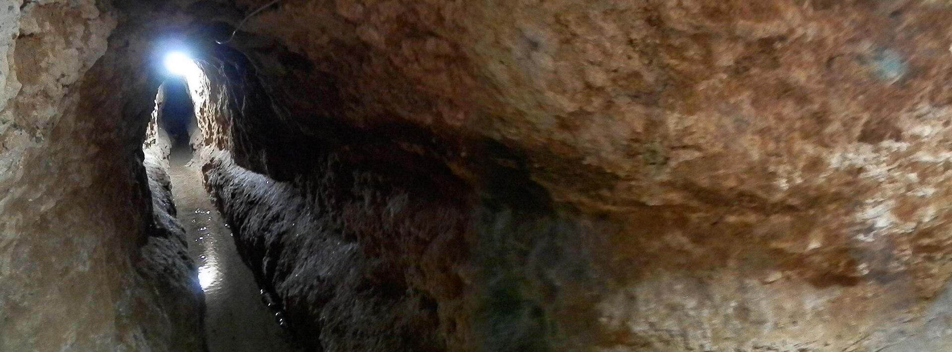
The eleven qanats that form the World Heritage property are still active water carriers, having retained not only their architectural and technological structures but also their function.
Qanat systems were in use in ancient Persia, India, Egypt and other Middle Eastern countries hundreds of years before the Romans, who are considered the greatest aqueduct builders of the ancient world, using tunnels tapped into hillsides to bring water for irrigation to the plains below.
3. Greek and Roman Engineering
On Samos, the fortified ancient city and its sanctuary were bound together as one site: the Pythagoreion comprises the ancient city and the Temple of Hera, the Heraion, which lies about 6 km away from the city and is indissolubly linked with it.
The Appian aqueduct was brought into the City by Appius Claudius Crassus, the Censor, who afterwards received the surname 'the Blind' and who had also charge of constructing the Appian Way as far as the city of Capua.
Vitruvius advises reservoirs at distances of twenty thousand feet from each other, because if damage be done to any part, the defective places will be more easily found and it will not be necessary to take the whole work to pieces.
Of the three instruments the chorobates is the best, inasmuch as the dioptra and the level are often found to be incorrect. The chorobates is a rod about twenty feet in length with two legs of equal length at its extremities, cross pieces fastened with tenons, and plumb lines hanging from the rod to show when the instrument stands level.
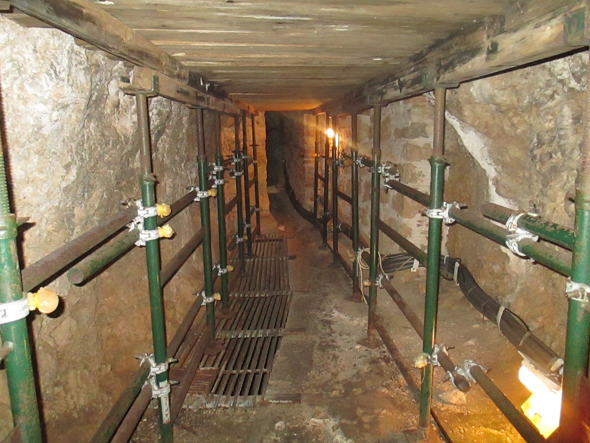
Forty years after the Appia was brought in, in the 481st year from the founding of the City, Manius Curius Dentatus contracted to have the waters of what is now called Old Anio brought into the City. One of the most famous features of the Pythagoreion is the Eupalinus tunnel dating from the 6th century BC, which runs 1036 m through the mountainside to bring water to the ancient city.
Only a portion of Rome's aqueduct system actually crossed over valleys on stone arches — 50 km out of a total of about 420 km — while the rest consisted of underground conduits made mostly of stone and terra-cotta pipe but also of wood, leather, lead and bronze.
4. Frontinus and the Administration of Rome's Water
The emperor Nerva laid upon Frontinus the duties of water commissioner, an office which concerns not merely the convenience but also the health and even the safety of the City, and which had always been administered by the most eminent men of the state. One hundred and twenty-seven years after the earlier conduits were built, when the conduits of Appia and Old Anio had become leaky by reason of age and water was being diverted from them unlawfully, the Senate commissioned Marcius to reclaim and repair them and to bring in a third supply, called Marcia after the man who introduced it.
Within the City, 9,955 quinariae were distributed to 247 reservoirs: 1,707½ in the name of Caesar, 3,847 to private parties and 4,401 for public uses — camps, public structures, thirty-nine ornamental fountains and 591 water-basins.
Having measured the intakes of the conduits, Frontinus discovered a total supply far greater than the imperial records showed, by about 10,000 quinariae. Frontinus set down 14,018 quinariae as the total discharge of all the aqueducts of Rome. The 4,401 quinariae assigned to public uses were divided among 111 camps, seventy-five public structures, 39 ornamental fountains and 591 water-basins.
5. Monumental Roman Aqueducts: Pont du Gard and Segovia
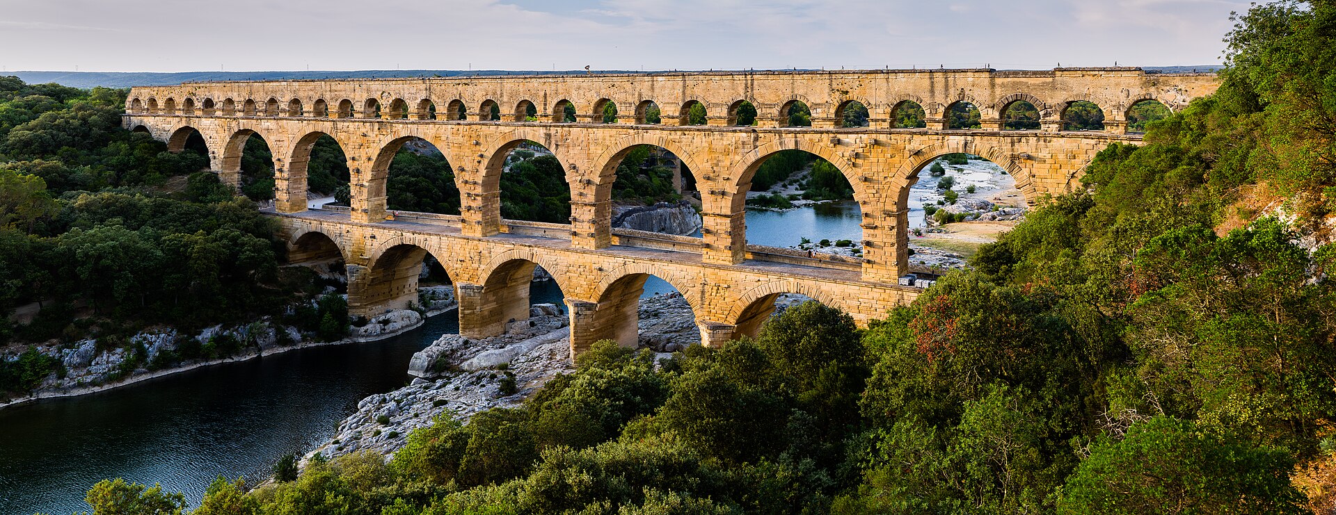
The Pont du Gard is the major element of a 50.02 km aqueduct built in the middle of the 1st century to supply the city of Nîmes, the ancient Roman colony of Nemausus, from the Eure source located near Uzès.
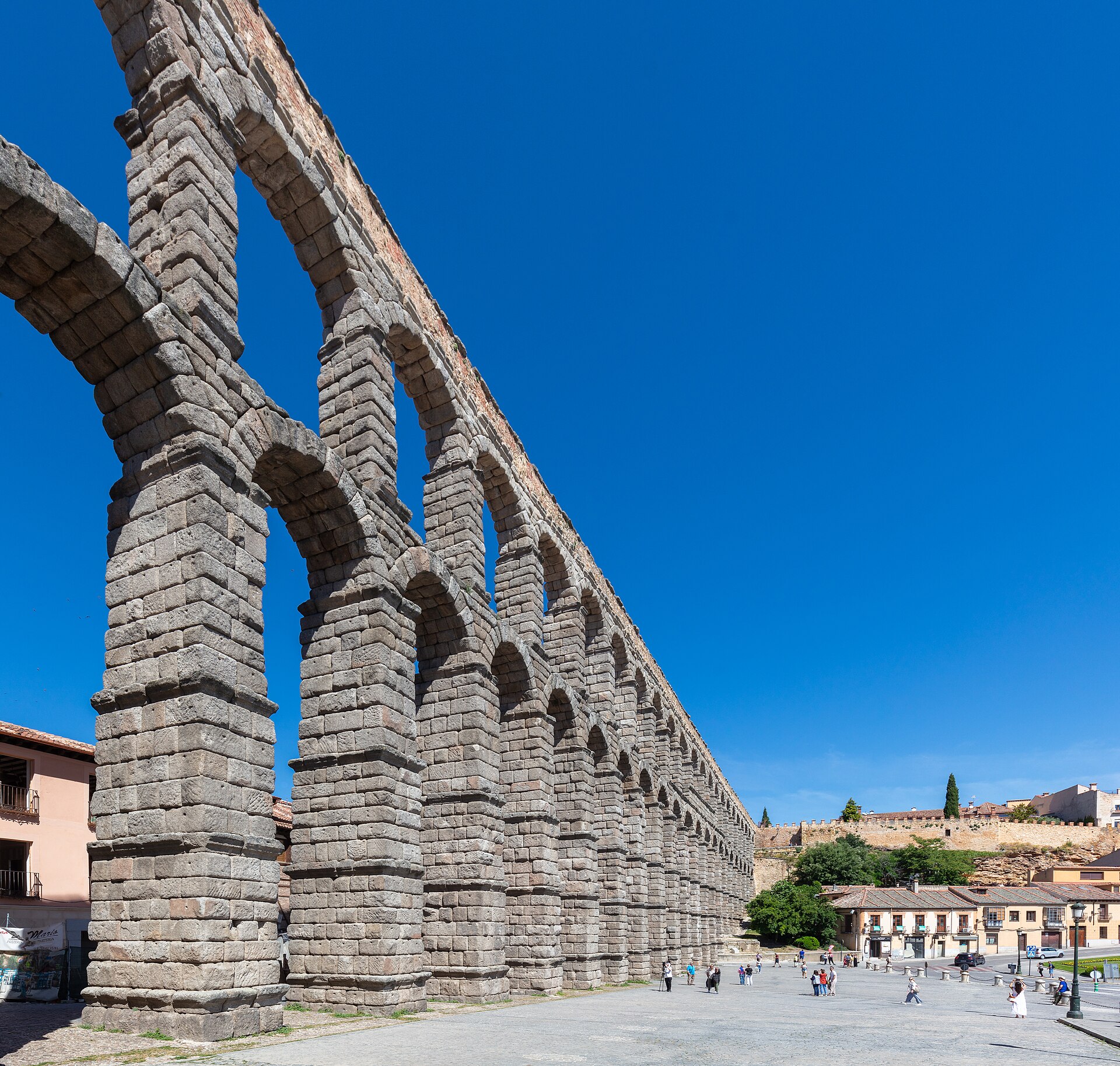
The Aqueduct of Segovia is an enormous construction of masonry 813 m in length, consisting of four straight segments and two superimposed arcades borne by 128 pillars; at the lowest point of the valley it stands 28.5 m above ground. It is the best known of Rome's civil engineering feats in Spain due to its monumentality and its excellent state of conservation, and Frontinus described aqueducts as 'the most solemn testimony of the Empire'.
In 1746 the construction of a road bridge attached to the first level of the Roman bridge was entrusted to the engineer Henri Pitot, who had the concern to adjust his work as exactly as possible to the ancient bridge.
The Pont du Gard stands almost 50 m high and is on three levels, the longest measuring 275 m.
The Roman Aqueduct of Segovia, probably built around 50 BC, is remarkably well preserved. Its impressive construction, with its two tiers of arches, forms part of the magnificent setting of the historic city of Segovia.
6. Decline and Revival
As central authority fell apart in the 4th and 5th centuries, the Roman systems deteriorated. For most of the Middle Ages aqueducts were not used in western Europe, and people returned to getting their water from wells and local rivers.
One of the major innovations of the 18th and 19th centuries was the introduction of steam pumps and the improvement of pressurized systems. Pumping water under pressure let a system follow the contours of the land, whereas earlier free-flowing systems had to maintain certain gradients over varied terrain.
7. Colonial and Industrial-Era Aqueducts
The monumental arcade bridging the Tepeyahualco Ravine and the Papalote River is made up of 68 round arches, integrating the highest single-level arcade ever built in aqueducts from Roman times until the middle of the 16th century.
The Pontcysyllte Aqueduct is a pioneering masterpiece of engineering and monumental metal architecture conceived by the celebrated civil engineer Thomas Telford; the use of both cast and wrought iron enabled the construction of arches that were light and strong. It is constructed using metal arches supported by tall, slender masonry piers.
The aqueduct of Padre Tembleque, named after the friar Francisco de Tembleque, was constructed between 1555 and 1572 and constitutes a hydraulic system located between the states of Mexico and Hidalgo on the Mexican Central Plateau.
The main arcaded aqueduct of Padre Tembleque at Tepeyahualco reaches a total height of 39.65 m, with its central arch standing 33.84 m high.
8. Nineteenth-Century Urban Supply: The Croton Aqueduct
The Croton Aqueduct was built in response to the fires and epidemics that repeatedly devastated New York City, owing in part to its inadequate water supply and contaminated wells. Designed on principles dating from Roman times, the gravity-fed tube dropped gently 13 inches per mile, challenging its builders to maintain a steady gradient through varied terrain.
After numerous proposals, construction of the Croton Aqueduct of unprecedented magnitude began in 1837 under the expertise of John Bloomfield Jervis. Three to four thousand workers, mostly Irish immigrants earning up to $1.00 per day, completed the masonry marvel of the Croton Aqueduct in just five years. For most of its length, the Croton Aqueduct is a horseshoe-shaped brick tunnel 8.5 feet high by 7.5 feet wide, set on a stone foundation and protected with an earthen cover.
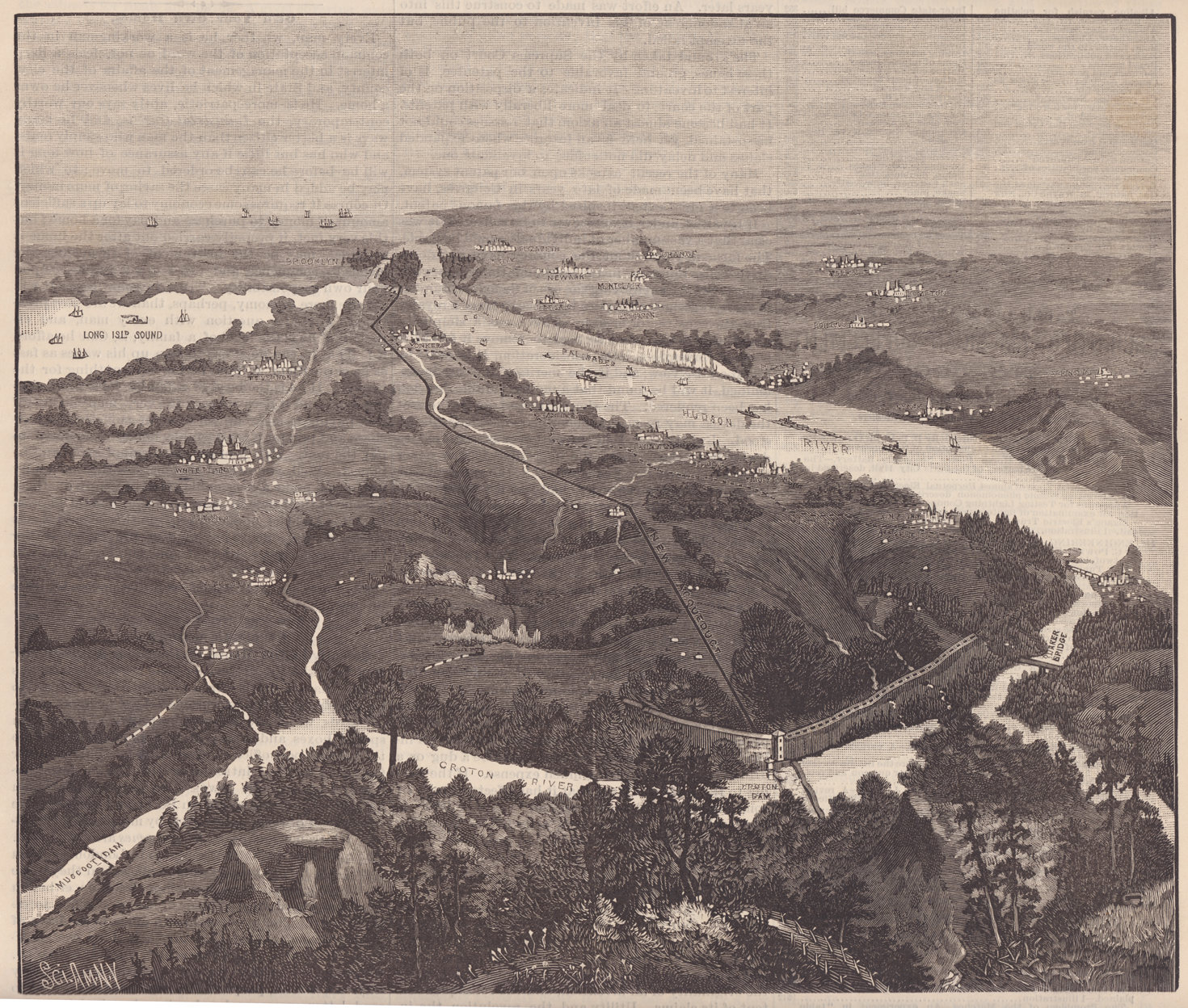
The Croton Aqueduct cost New York City approximately 13 million dollars and was capable of carrying 100 million gallons per day, but could no longer meet New York City's needs by the early 1880s.
9. The American West: Los Angeles and the Colorado River
The Colorado River Aqueduct was originally conceived by William Mulholland and designed by Metropolitan's first Chief Engineer Frank Weymouth after consideration of more than 50 routes. Stretching 242 miles from the Colorado River on the California-Arizona border to its final holding reservoir near Riverside, it consists of more than 90 miles of tunnels, nearly 55 miles of cut-and-cover conduit, almost 30 miles of siphons and five pumping stations. Builders added five pumping plants to lift water over mountains so that deliveries could then flow west by gravity, and blasted 90-plus miles of tunnels, including a waterway under Mount San Jacinto. The Lake Mathews reservoir was selected because its elevation of nearly 1,400 feet allows water to flow by gravity to the majority of Metropolitan's service area; the CRA was the largest public works project built in Southern California during the Great Depression.
In 1905 the citizens of Los Angeles voted a bond issue of $1.5 million to purchase Owens Valley lands and water rights. Two years later voters approved another $23 million bond issue for construction of a 233-mile long aqueduct. The first aqueduct water was presented to the people of Los Angeles on 5 November 1913 in a ceremony at which Mulholland declared 'There it is — take it'. As the population grew, the Department built a 177-mile second aqueduct from the Owens Valley, completed in 1970 and able to bring an additional annual flow of 152,000 acre feet to Los Angeles. The Colorado River Aqueduct was funded by a bond issue of $220 million approved by voters in 1931 and is capable of lifting more than 1,600 cubic feet of water per second to a static height of 1,600 feet.
10. California and Arizona: Modern Systems
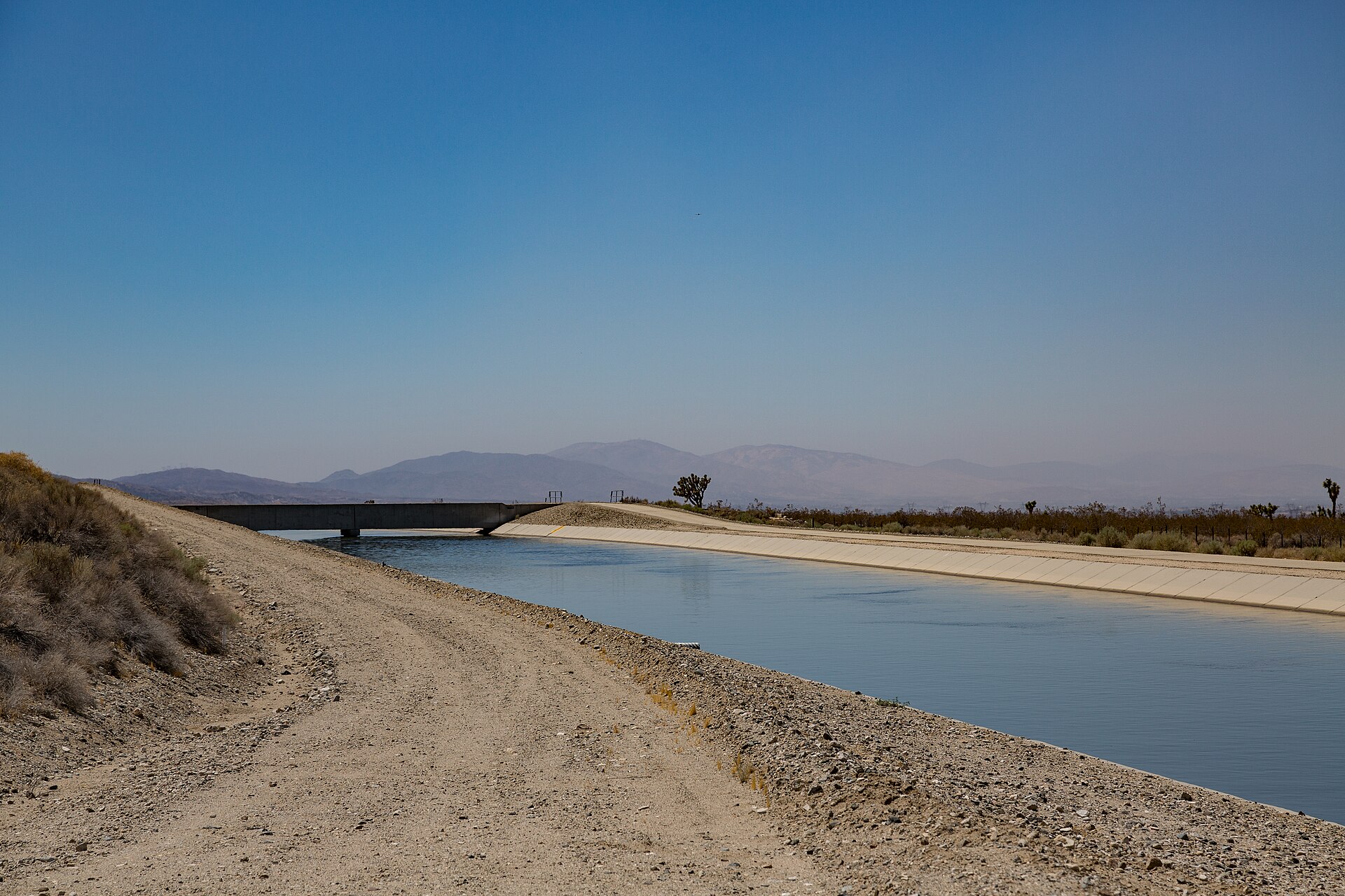
The California Aqueduct is the primary method of transporting water from Northern California to Southern California; the concrete-lined canal moves water from the Clifton Court Forebay in the Sacramento-San Joaquin Delta down to Lake Perris, the project's southernmost reservoir. At the Tehachapi Mountains, water is lifted 1,926 feet by fourteen 80,000 horsepower pumps at Edmonston Pumping Plant, the highest single-lift pumping plant in the world.
The Central Arizona Project is a 336-mile long system of aqueducts, tunnels, pumping plants and pipelines. Constructed in the 1960s and 1970s, the State Water Project is a network of dams, canals and pumping plants that store and deliver water to people, farms and industry.
The 336-mile Central Arizona Project canal begins at Lake Havasu and ends at its terminus just south of Tucson. CAP supplies Colorado River water to the most populated regions in Arizona and delivers more tribal water than any other organization in the United States.
The State Water Project spans more than 705 miles from Northern California to Southern California and includes 36 storage facilities, 21 pumping plants, five hydroelectric power plants, four pumping-generating plants and approximately 700 miles of canals, tunnels and pipelines.
11. Timeline: from the Assyrian aqueduct at Nineveh to the California Aqueduct
- about 691 BCEAssyrian aqueduct at NinevehA limestone aqueduct built by the Assyrians brought fresh water to the city of Nineveh, its channel made of about two million large blocks and crossing a valley.
- 6th century BCEEupalinus' tunnel on SamosOn Samos, the Eupalinus tunnel ran 1036 m through the mountainside to bring water to the ancient city, the work of Eupalinus of Megara.
- 312 BCERome's aqueduct programme beginsOver a period of 500 years — from 312 BCE to 226 CE — 11 aqueducts were built to bring water to Rome from as far away as 92 km; some of them are still in use.
- c. 50 BCAqueduct of SegoviaThe Roman Aqueduct of Segovia, probably built around 50 BC, survives remarkably well preserved; the masonry structure is 813 m long and stands 28.5 m high at the lowest point of the valley.
- mid-1st century CEThe Pont du GardThe Pont du Gard was built to carry the 50.02 km aqueduct of Nîmes, the Roman colony of Nemausus, across the Gardon River.
- 4th–5th centuries CEAqueducts deteriorateAs central authority fell apart in the 4th and 5th centuries, the Roman water systems also deteriorated.
- early 6th centuryNîmes aqueduct ceases to functionThe aqueduct of Nîmes ceased to function around the beginning of the 6th century and the Pont du Gard never regained its original use.
- 1746Pitot's road bridge at the Pont du GardA road bridge attached to the first level of the Roman bridge was entrusted to the engineer Henri Pitot, who adjusted his work as exactly as possible to the ancient bridge.
- 1805Pontcysyllte Aqueduct completedThomas Telford's Pontcysyllte Aqueduct and Canal, an 18 km waterway carried on cast- and wrought-iron arches, was completed in the early 19th century.
- October 14, 1842Croton Aqueduct opensNew York City's 41-mile Croton Aqueduct opened to public use with a formal celebration, bringing fresh water from the Croton River.
- November 5, 1913Los Angeles AqueductThe first Los Angeles Aqueduct water was presented to the city on November 5, 1913, when Mulholland said: 'There it is: take it.'
- 1933–1941Colorado River AqueductConstruction of the 242-mile Colorado River Aqueduct began in 1933 and was completed in 1939; the regional distribution system became operational in 1941.
- 1960s–1970sState Water Project and California AqueductThe State Water Project, a network of dams, canals and pumping plants including the California Aqueduct, was constructed in the 1960s and 1970s.
- 1970Second Los Angeles AqueductA 177-mile second aqueduct from the Owens Valley was completed in 1970, adding an annual flow of 152,000 acre feet to Los Angeles.
- 2009Pontcysyllte inscribed by UNESCOThe Pontcysyllte Aqueduct and Canal were inscribed on the UNESCO World Heritage List in 2009 as a masterpiece of Industrial Revolution civil engineering.
References (18)
- 1Aqueduct | Definition, History, & Facts — Encyclopaedia Britannica WebView source
- 2The Persian Qanat — UNESCO World Heritage Centre 1506 WebView source
- 3Pythagoreion and Heraion of Samos — UNESCO World Heritage Centre WebView source
- 4The Aqueducts of Rome (De aquis urbis Romae), Book I — trans. Charles E. Bennett — LacusCurtius, University of Chicago BookView source
- 5Vitruvius: The Ten Books on Architecture, Book VIII (Water Supply) — trans. Morris Hicky Morgan — LacusCurtius, University of Chicago BookView source
- 6The Aqueducts of Rome (De aquis urbis Romae), Book II — trans. Charles E. Bennett — LacusCurtius, University of Chicago BookView source
- 7Pont du Gard (Roman Aqueduct) — UNESCO World Heritage Centre WebView source
- 8Old Town of Segovia and its Aqueduct — UNESCO World Heritage Centre WebView source
- 9Aqueduct of Padre Tembleque Hydraulic System — UNESCO World Heritage Centre WebView source
- 10Pontcysyllte Aqueduct and Canal — UNESCO World Heritage Centre WebView source
- 11History — Friends of the Old Croton Aqueduct WebView source
- 12Old Croton Aqueduct State Historic Park — New York State Parks, Recreation and Historic Preservation WebView source
- 13Water System Past and Present — Los Angeles Department of Water and Power WebView source
- 14Colorado River Aqueduct — Historic Landmarks — American Society of Civil Engineers WebView source
- 15SWP Facilities — California Department of Water Resources WebView source
- 16About Central Arizona Project — Central Arizona Project WebView source
- 17Water Storage & Supply — California Department of Water Resources WebView source
- 18Fact Sheet: The Colorado River Aqueduct (July 2021) — The Metropolitan Water District of Southern California 2021 WebView source