Lake Ontario
The smallest Great Lake by surface area and the most easterly — geology, water levels and storms, the War of 1812 and the Rush–Bagot naval pact, the St. Lawrence Seaway, and the shoreline cities of the Golden Horseshoe.
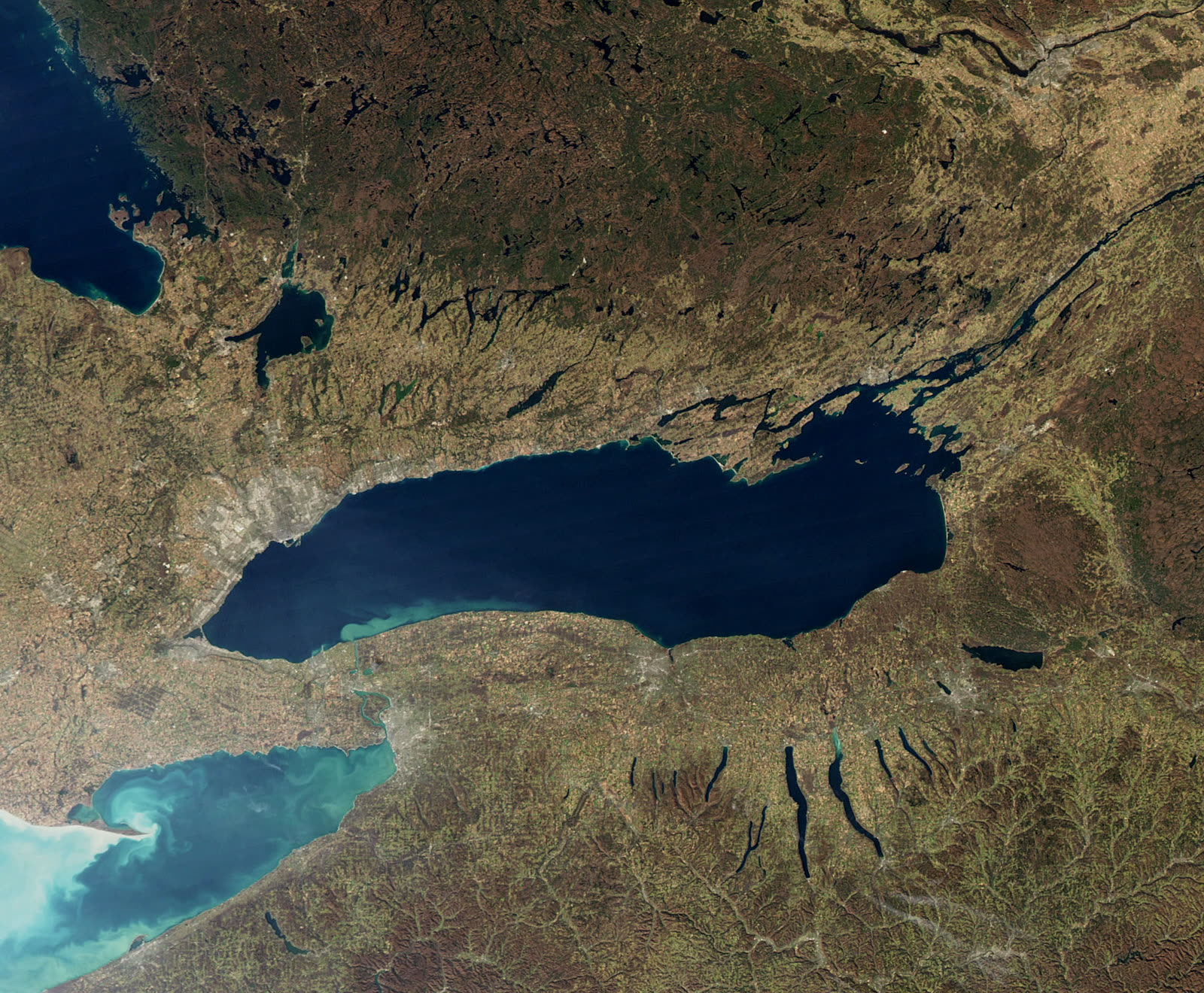
Lake Ontario is the smallest of the Great Lakes by surface area — about 19,000 km² — and the most easterly, lying between Ontario, Canada, and New York State. Most of its water arrives from the upper lakes via the Niagara River, and it drains to the Atlantic through the St. Lawrence River at Kingston. Its shoreline carries Toronto, Hamilton and the industrial Golden Horseshoe, and its history runs from Iroquois settlement and French forts through the War of 1812, the Rush–Bagot naval pact and the St. Lawrence Seaway. Today it combines record-high water levels, binational restoration of Areas of Concern, and sustained pressure from invasive species.
In this article
- 1Overview
- 2Physical Characteristics
- 3Geography and Hydrology
- 4Geological Origins and Lake Floor
- 5Climate and Water Levels
- 6Name and History
- 7Human Geography and Economy
- 8Ecology and Environmental Issues
- 9Governance and Management
- 10Cultural and Scientific Connections
- 11Timeline: from glacial lakes to the St. Lawrence Seaway
- 12Frequently asked questions
- 13Knowledge graph
Overview
Lake Ontario is the smallest of the Great Lakes by surface area, the most easterly of them, and the eighth-largest body of fresh water in North America. It is bounded on the north by Ontario, Canada, and on the south by New York State, United States. The name is Iroquoian, signifying "beautiful lake" or "sparkling water". Europeans first applied the name "Ontario" to the lake in 1641, and it appears on maps of North America as early as 1656.
The lake's water surface area is given as 7,340 square miles (19,009 square kilometres). Of the lake's 18,960 square kilometres, about 10,049 square kilometres lie within Canada. Its mean depth is 283 feet (86 metres), and its maximum depth is 802 feet (244 metres). The surface sits 243 feet (74 metres) above sea level.
Lake Ontario has a volume of 393 cubic miles (1,640 cubic kilometres). It holds the twelfth-largest volume of any freshwater lake in the world, yet it is the second-smallest of the Laurentian Great Lakes. Though similar to Lake Erie in length and breadth, its greater average depth gives it almost four times Erie's volume and a retention time of about six years. About 86% of its water arrives from the upper Great Lakes and Lake Erie via the Niagara River, and the lake drains to the St.
1. Physical Characteristics
Lake Ontario is the smallest of the Great Lakes by surface area, the most easterly of them, and the eighth-largest body of fresh water in North America 1Lake Ontario · The Canadian Encyclopedia (Historica Canada) ↗. Its surface area is given as 7,340 square miles, or 19,009 square kilometres 2Lake Ontario — National Marine Ecosystem Status · U.S. National Oceanic and Atmospheric Administration (NOAA) ↗. Of the lake's 18,960 square kilometres, 10,049 square kilometres lie within Canada 1. The lake is bounded on the north by Ontario, Canada, and on the south by New York State, United States 24Lake Ontario · Encyclopaedia Britannica ↗.
The lake's mean depth is 283 feet (86 metres), and its maximum depth reaches 802 feet (244 metres) 3Physical Features of the Great Lakes | US EPA · U.S. Environmental Protection Agency (EPA) ↗. Its surface sits 243 feet (74 metres) above sea level 24. It measures 193 miles by 53 miles (311 kilometres by 85 kilometres) 24. Its drainage basin covers 24,720 square miles (64,025 square kilometres), excluding the lake itself 24.
The lake's retention time is six years 3. Its 30-mile-wide eastern end is crossed by a chain of five islands, where it discharges into the St. Lawrence River near Kingston, Ontario 24.
| Attribute | Value |
|---|---|
| Surface area | 7,340 sq mi (19,009 km²) 2 |
| Area within Canada | 10,049 km² of the lake's 18,960 km² 1 |
| Mean depth | 283 ft (86 m) 3 |
| Maximum depth | 802 ft (244 m) 3 |
| Surface elevation | 243 ft (74 m) above sea level 24 |
| Length by width | 193 mi by 53 mi (311 km by 85 km) 24 |
| Retention time | 6 years 3 |
| Drainage basin | 24,720 sq mi (64,025 km²) 24 |
2. Geography and Hydrology
Lake Ontario measures 193 miles by 53 miles (311 kilometres by 85 kilometres), a long and comparatively narrow shape that gives the lake its distinctive proportions. Its surface rests 243 feet (74 metres) above sea level. The lake is the smallest of the Great Lakes by surface area, the most easterly of them, and the eighth-largest body of fresh water in North America.
The Niagara River is the lake's primary inflow. Most of the lake's water arrives from the other Great Lakes by way of that river, and the lake discharges into the St. Lawrence River through the Kingston Basin at its northeast end. The outflow leaves by the St. Lawrence River at Kingston, Ontario.
The drainage basin covers 24,720 square miles (64,025 square kilometres). The shoreline, including islands, runs 712 miles (1,146 kilometres). Principal port cities on the lake are Toronto, Hamilton and Kingston in Ontario, together with Rochester and Oswego in New York.
At the lake's 30-mile-wide eastern end, a chain of five islands crosses the water. It is there that the lake discharges into the St. Lawrence River near Kingston, Ontario.
3. Geological Origins and Lake Floor
Lake Ontario rests within a bedrock depression that was first carved by stream erosion and subsequently reshaped by glaciation. Its present level and its outlet were established roughly 11,000 years ago. The lake is the smallest of the Great Lakes by surface area, the most easterly of them, and the eighth-largest body of fresh water in North America.
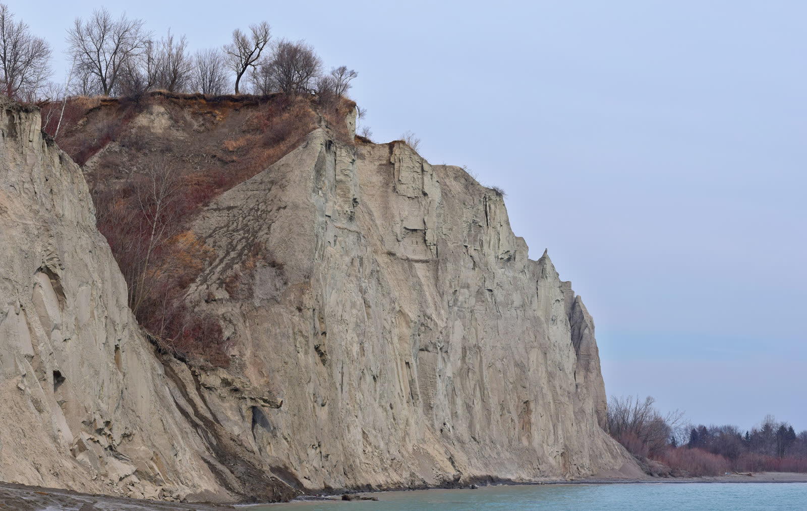
Near Toronto, the Scarborough Bluffs rise as high as 100 metres above the lake, marking the point where older glacial and lake deposits meet.
Charity Shoal is a small circular depression with an encircling rim that remains unexplained. Its form resembles that of a simple impact crater.
The Duck–Galloo Ridge on the lake floor consists of north-facing cuestas formed on resistant Ordovician limestones. In the Rochester Basin, linear ridges resemble the drumlin fields found north of the lake. These features may record the flow of advancing ice or of subglacial meltwater.
4. Climate and Water Levels
Lake Ontario is a deep body of water, and its winter climate is moderated from the southwest; as a result, its open waters rarely freeze. The main body of the lake is well mixed from November to May and stratified from June to October. Freezing is confined to the margins: the lake freezes only near the land, and its harbours are icebound from mid-December to mid-April.
Great Lakes water levels form one of North America's longest high-quality hydrometeorological data sets, with U.S. reference gauge records beginning in 1860. The lakes are generally at their lowest levels in winter and highest in summer or fall, with an annual rise ranging from 11 to 20 inches. Lake Ontario set a record-high water level in 2017 of 75.88 m, then exceeded it just two years later in 2019 with a new record of 75.92 m.
No regulation plan can eliminate high-water events on Lake Ontario or the St. Lawrence; regulation can only reduce peak levels and shorten recovery time compared with pre-dam conditions.
5. Name and History
The name Ontario is thought to be of Iroquoian origin, meaning 'beautiful lake' or 'sparkling water'. Europeans first applied the name 'Ontario' to the lake in 1641, and it appears on maps of North America as early as 1656. The French scout Étienne Brûlé was the first European known to have visited the lake, in 1615, and Samuel de Champlain also visited it that year.
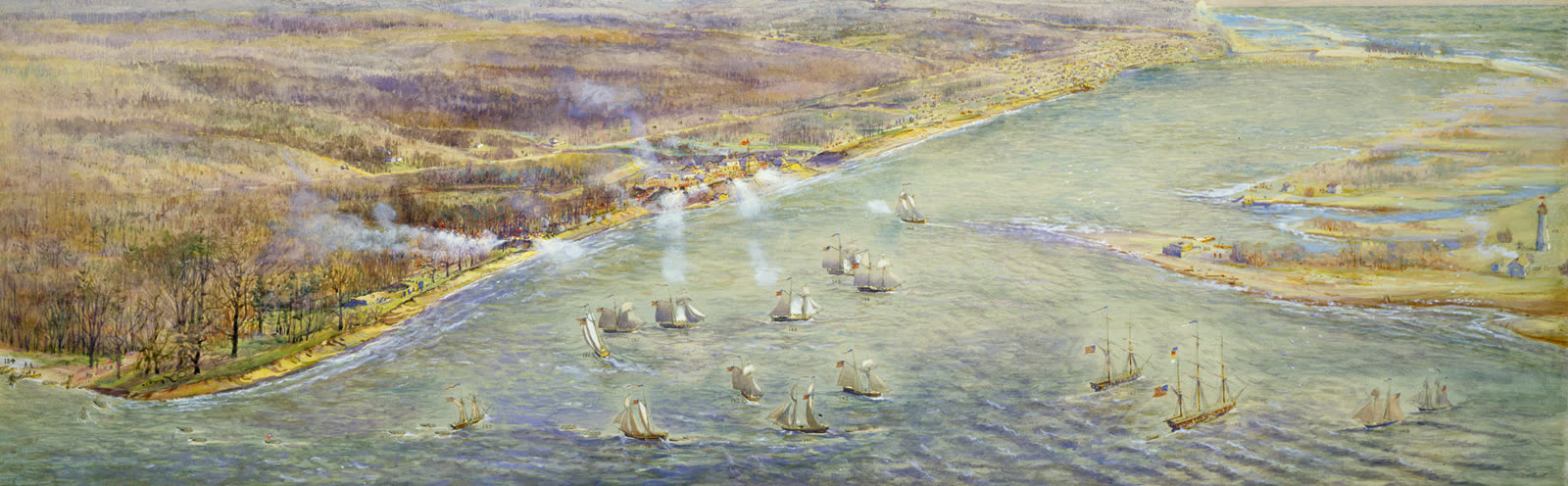
Fort Frontenac stood at the mouth of the Cataraqui River, the site of present-day Kingston, Ontario, and construction began in July 1673. Although reinforced by French troops, the fort fell to the British under John Bradstreet in August 1758. After 1783 the British re-established Kingston as a major military and naval base; the older fortifications of Frontenac were abandoned and eventually buried as the city grew.
The first major group of settlers were Loyalists, many of whom settled on the north shore, and the most vigorous campaigns of the War of 1812 were fought on or near Lake Ontario. A crushing defeat for the British in that war, the sacking of York — today's Toronto — began on the morning of 27 April 1813. Under the Rush–Bagot Pact, the United States and Great Britain agreed to eliminate their fleets from the Great Lakes, except for small patrol vessels, and the U.S. Senate ratified the agreement on 28 April 1818.
Between 5 and 16 October 1954, Hurricane Hazel tracked across the Great Lakes, merged with a cold front and dropped record rainfall on the Greater Toronto Area. Hurricane Hazel struck the Toronto area on 15–16 October 1954; it was Canada's worst hurricane and Toronto's worst natural disaster. The Seaway opened to commercial traffic on 25 April 1959; its official opening on 26 June 1959 was attended by Prime Minister John Diefenbaker, President Dwight D. Eisenhower and Queen Elizabeth II.
6. Human Geography and Economy
The population living along Lake Ontario numbers about 5.6 million, divided roughly evenly between the two nations that share its shores, with about 2.8 million in Canada and about 2.8 million in the United States. The lake is bounded on the north by Ontario, Canada, and on the south by New York State, United States. Its drainage basin covers parts of Ontario and New York and a small portion of Pennsylvania.
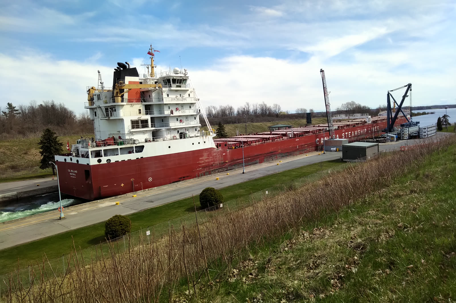
The principal port cities on the lake are Toronto, Hamilton and Kingston in Ontario, and Rochester and Oswego in New York. Hamilton and Toronto rank among the major urban centres on its shore. The lake's outflow is the St. Lawrence River at Kingston, Ontario, and its primary inflow is the Niagara River.
More than 55 per cent of Ontario's population lives near the lake. The 'Golden Horseshoe' around its western end, including St. Catharines, Hamilton and Toronto, is Canada's industrial heartland.
Settlement and growth around the lake were aided by the farmland of southern Ontario and access to ocean shipping via the St. Lawrence Seaway and to upper Great Lakes ports via the Welland Canal. Between Lakes Ontario and Erie, the Welland Canal bypasses Niagara Falls; its eight locks lift a westbound vessel 99.4 m over 43.5 km. New York's canal system, whose waterways link Lake Ontario to the Atlantic seaboard, has been in continuous operation since 1825 — longer than any other constructed transportation system in North America.
7. Ecology and Environmental Issues
Phosphorus management mandated by the 1972 Great Lakes Water Quality Agreement cut phosphorus concentrations and played an integral role in shaping Lake Ontario's fish communities. The agreement thus stands as an early instance of binational regulation directed at the lake's water quality. Its effects extended beyond chemistry into the composition of the lake's living resources.
In the 1990s zebra and quagga mussels spread explosively in the lake. Water clarity rose through their filtering. Submerged plants expanded in sheltered nearshore areas.
Sea lamprey control began in 1971 and eventually improved the survival of stocked salmon and trout. Large-scale stocking of salmon and trout in the 1980s restored the balance between the lake's predators and alewife, the dominant offshore prey fish. Together these measures reshaped the relationship between predator and prey in the open lake.
The round goby, an invasive fish found in Lake Ontario, can outcompete native white sucker fish. Native white suckers swim upstream each spring to spawn and leave nutrients behind in eggs and dead bodies. Losing them to round goby would affect the entire nutrient cycling of Lake Ontario.
Areas of Concern are Great Lakes locations that suffered high levels of environmental harm. The Canada–United States Great Lakes Water Quality Agreement identified 43 of them — 12 Canadian and 5 shared. On Lake Ontario, Canada's Areas of Concern are Hamilton Harbour, Toronto and Region, Port Hope Harbour and the Bay of Quinte.
Based on nine State of the Great Lakes indicators, the overall status of the Lake Ontario basin ecosystem is rated 'Fair'. The trend is described as 'Unchanging to Improving'.
8. Governance and Management
The International Lake Ontario–St. Lawrence River Board ensures that outflows from Lake Ontario meet the requirements of the International Joint Commission's Orders of Approval, and it communicates with the public. Its work sits within a lake whose outflow is the St. Lawrence River at Kingston, Ontario. The lake's 30-mile-wide eastern end is crossed by a chain of five islands, where it discharges into the St. Lawrence River near Kingston, Ontario.
The Lakewide Action and Management Plans (LAMPs) are binational Canada–United States action plans for restoring and protecting the Great Lakes ecosystem, under the Great Lakes Water Quality Agreement. The lake is bounded on the north by Ontario, Canada, and on the south by New York State, United States. Areas of Concern are Great Lakes locations that suffered high levels of environmental harm; the Canada–United States Great Lakes Water Quality Agreement identified 43 of them — 12 Canadian and 5 shared. Phosphorus management mandated by the 1972 Great Lakes Water Quality Agreement cut phosphorus concentrations and played an integral role in shaping Lake Ontario's fish communities.
The USGS Great Lakes Science Center, part of the agency's Midcontinent Region, supplies scientific information that resource managers use to restore, enhance, manage and protect living resources and habitats in the Great Lakes basin. One official seasonal water-level forecast for the Great Lakes is issued jointly each month by the U.S. Army Corps of Engineers–Detroit District and Environment and Climate Change Canada's Great Lakes–St. Great Lakes water levels form one of North America's longest high-quality hydrometeorological data sets, with U.S. reference gauge records beginning in 1860.
Queen's University sits on the shore of Lake Ontario next to the wetland-rich Frontenac Arch UNESCO biosphere reserve, ideally placed for research into freshwater ecology. Queen's faculty take part in the Great Lakes Research Consortium, a group of 18 universities in New York and Ontario researching the Great Lakes ecosystem.
9. Cultural and Scientific Connections
The name of Lake Ontario has a counterpart far from Earth: Ontario Lacus, the largest lake in the southern hemisphere of Saturn's moon Titan, was imaged by NASA's Cassini spacecraft on 12 January 2010. That extraterrestrial body has a surface area of about 15,000 square kilometres (6,000 square miles), slightly smaller than its terrestrial namesake, Lake Ontario. The pairing of the two names links a body of liquid on a distant moon to the smallest of the Great Lakes by surface area.
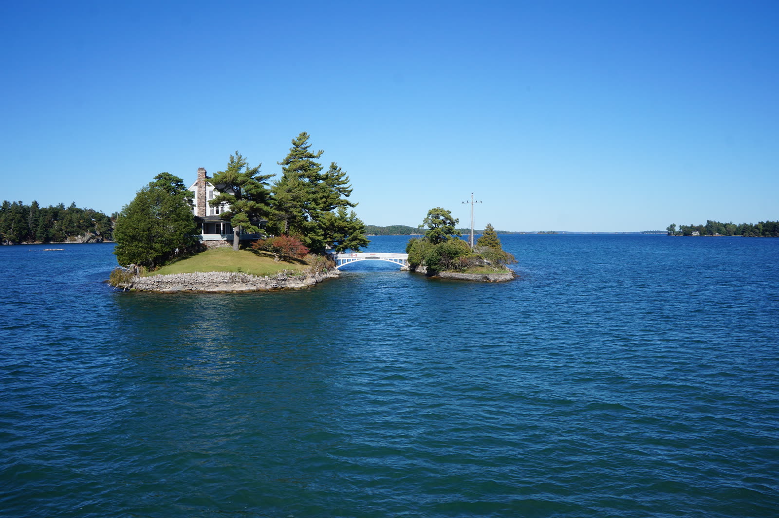
At the lake's eastern end, Thousand Islands National Park protects granite islands of the St. Lawrence River in a transition zone between the Canadian Shield and the Adirondack Mountains. This protected archipelago lies in the same river corridor through which Lake Ontario discharges, for the lake empties into the St. Lawrence River near Kingston, Ontario. The lake's 30-mile-wide eastern end is crossed by a chain of five islands at that discharge point.
South of the lake, the Erie Canalway National Heritage Corridor was established by Congress in 2000 and spans 524 miles, including the Erie, Cayuga–Seneca, Oswego and Champlain canals. The corridor commemorates a canal network that tied the lake's southern shore to inland and coastal routes, complementing the access to ocean shipping via the St. Lawrence Seaway and to upper Great Lakes ports via the Welland Canal that aided settlement and growth around the lake. Principal port cities on the lake include Toronto, Hamilton and Kingston in Ontario, and Rochester and Oswego in New York.
10. Timeline: from glacial lakes to the St. Lawrence Seaway
- about 11,000 years agoGlacial lakes give way to the modern lakeAncient glacial lakes of varying elevation had occupied the basin; the lake's present level and outlet were established about 11,000 years ago.
- 1615First European visitorsÉtienne Brûlé, a French scout, and Samuel de Champlain visited Lake Ontario in 1615; Brûlé is the first European known to have seen the lake.
- 1641The name 'Ontario' enters European mapsEuropeans first applied the name 'Ontario' to the lake in 1641, and it appears on maps of North America as early as 1656.
- July 1673Fort Frontenac founded at KingstonConstruction of Fort Frontenac began in July 1673 at the mouth of the Cataraqui River, the site of present-day Kingston, Ontario; the French fort secured fur-trade routes on the lake.
- August 1758Fort Frontenac falls to the BritishReinforced by French troops, Fort Frontenac nevertheless fell to the British under John Bradstreet in August 1758.
- 1783Kingston rebuilt as a British baseAfter 1783 the British re-established Kingston as a major military and naval base, building Fort Henry overlooking the harbour.
- 27 April 1813Sacking of York in the War of 1812A crushing defeat for the British, the sacking of York (today's Toronto) began on the morning of 27 April 1813; the Americans burned the Parliament and other public buildings.
- 1817 (ratified 28 April 1818)Rush-Bagot Pact demilitarizes the Great LakesThe United States and Great Britain agreed to remove their fleets from the Great Lakes, limiting military navigation to one or two vessels per country on each lake; the U.S. Senate ratified the pact on 28 April 1818.
- 1825Canal era links the lake to the Atlantic seaboardNew York's canal system, which includes the Oswego Canal connecting Lake Ontario to the Erie Canal, has been in continuous operation since 1825 — longer than any other constructed transportation system in North America.
- 15–16 October 1954Hurricane Hazel floods Toronto from the lakeHurricane Hazel struck the Toronto area on 15–16 October 1954; winds reached 124 km/h and over 200 mm of rain fell in 24 hours, leaving 81 dead and nearly 1,900 families homeless.
- 25 April 1959St. Lawrence Seaway opensThe Seaway opened to commercial traffic on 25 April 1959, linking Lake Ontario to the Atlantic; the official opening on 26 June 1959 was attended by Prime Minister Diefenbaker, President Eisenhower and Queen Elizabeth II.
- 2017 and 2019Record-high water levels on Lake OntarioLake Ontario set a record-high water level in 2017 (75.88 m) and exceeded it in 2019 (75.92 m), as extreme water supplies overwhelmed regulation.
- 2026U.S. executive order renames the lake 'Lake America'In 2026 U.S. President Donald Trump issued an executive order renaming the lake 'Lake America' in U.S. usage; Lake Ontario remains its established name in Canada and in historical usage.
11. Frequently asked questions
How large is Lake Ontario, and how deep does it get?
Lake Ontario covers 7,340 square miles (19,009 square kilometres) and measures 193 miles by 53 miles (311 kilometres by 85 kilometres) 224. Its mean depth is 283 feet (86 metres), while the deepest point reaches 802 feet (244 metres) 3. The lake holds a volume of 393 cubic miles (1,640 cubic kilometres) 3.
Where does Lake Ontario's water come from, and where does it go?
Which countries and cities border Lake Ontario?
Lake Ontario is bounded on the north by Ontario, Canada, and on the south by New York State, United States 24. Its principal port cities are Toronto, Hamilton and Kingston in Ontario, and Rochester and Oswego in New York 24. About 5.6 million people live along the lake, roughly 2.8 million each in Canada and the United States 2.
How did Lake Ontario get its name?
Does Lake Ontario freeze over in winter?
References (24)
- 1Lake Ontario — The Canadian Encyclopedia (Historica Canada) Web↩View source
- 2Lake Ontario — National Marine Ecosystem Status — U.S. National Oceanic and Atmospheric Administration (NOAA) Web↩View source
- 3Physical Features of the Great Lakes | US EPA — U.S. Environmental Protection Agency (EPA) Web↩View source
- 4The State of Lake Ontario in 2014 (Special Publication 2017-02) — Great Lakes Fishery Commission / Sea Lamprey Control Centre 2014 WebView source
- 5Lake Ontario — About the Lakes — Great Lakes Commission WebView source
- 6Bathymetry of Lake Ontario: Additional Information — NOAA National Centers for Environmental Information (NCEI) WebView source
- 7Water Levels — NOAA Great Lakes Environmental Research Laboratory — NOAA Great Lakes Environmental Research Laboratory (GLERL) WebView source
- 8Impacts of the Extreme 2019 Great Lakes High Water Levels Felt Throughout Lake Ontario and the St. Lawrence River — International Joint Commission (IJC) 2019 WebView source
- 9Fort Frontenac — The Canadian Encyclopedia (Historica Canada) WebView source
- 10The Battle of York — The Canadian Encyclopedia (Historica Canada) WebView source
- 11Rush-Bagot Pact, 1817 and Convention of 1818 — U.S. Department of State, Office of the Historian 1817 WebView source
- 12Archived: Hurricane Hazel — Storm Information — Environment and Climate Change Canada WebView source
- 13Hurricane Hazel — The Canadian Encyclopedia (Historica Canada) WebView source
- 14St. Lawrence Seaway — The Canadian Encyclopedia (Historica Canada) WebView source
- 15Erie Canalway National Heritage Corridor — U.S. National Park Service (NPS) WebView source
- 16'The problem is going to get worse': U of T Scarborough researcher sounds alarm on invasive species — University of Toronto WebView source
- 17Great Lakes: Areas of Concern — Government of Canada (Canada Water Agency) WebView source
- 18International Lake Ontario-St. Lawrence River Board — International Joint Commission (IJC) WebView source
- 19Lake America LAMPs and Associated Reports | US EPA — U.S. Environmental Protection Agency (EPA) WebView source
- 20Great Lakes Science Center — U.S. Geological Survey (USGS) WebView source
- 21SDG 14: Life Below Water — Queen's contributions to the UN Sustainable Development Goals — Queen's University WebView source
- 22Footprint of Ontario Lacus (PIA13172) — NASA Science (NASA/JPL-Caltech) WebView source
- 23Thousand Islands National Park — Plan your visit — Parks Canada WebView source
- 24Lake Ontario — Encyclopaedia Britannica Web↩View source
 Isaac Newton
 The Cold War
 French Revolution
